You are here: Home > Network List > CI - Caltech Regional Seismic Network Stations List
> Station PAS Pasadena, Pasadena, CA, USA > Earthquake Result Viewer
PAS Pasadena, Pasadena, CA, USA - Earthquake Result Viewer
| Earthquake location: |
South Of Panama |
| Earthquake latitude/longitude: |
6.0/-82.7 |
| Earthquake time(UTC): |
2000/12/12 (347) 05:26:45 GMT |
| Earthquake Depth: |
10 km |
| Earthquake Magnitude: |
5.8 MB, 5.7 MS, 6.3 ME, 6.1 MW |
| Earthquake Catalog/Contributor: |
WHDF/NEIC |
|
| Network: |
CI Caltech Regional Seismic Network |
| Station: |
PAS Pasadena, Pasadena, CA, USA |
| Lat/Lon: |
34.15 N/118.17 W |
| Elevation: |
314 m |
|
| Distance: |
43.1 deg |
| Az: |
315.233 deg |
| Baz: |
122.378 deg |
| Ray Param: |
0.07274659 |
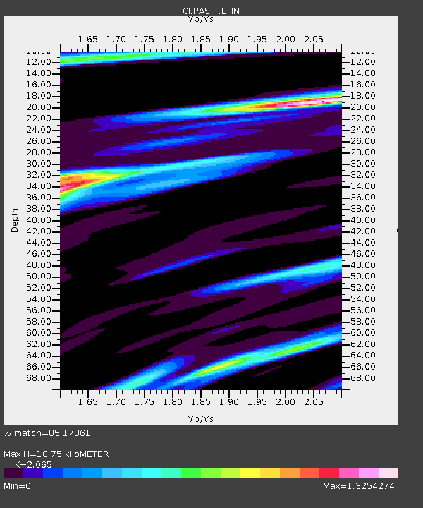
| Estimated Moho Depth: |
18.75 km |
| Estimated Crust Vp/Vs: |
2.07 |
| Assumed Crust Vp: |
6.1 km/s |
| Estimated Crust Vs: |
2.954 km/s |
| Estimated Crust Poisson's Ratio: |
0.35 |
|
| Radial Match: |
85.17861 % |
| Radial Bump: |
289 |
| Transverse Match: |
70.18088 % |
| Transverse Bump: |
400 |
| SOD ConfigId: |
3744 |
| Insert Time: |
2010-02-25 23:54:04.064 +0000 |
| GWidth: |
2.5 |
| Max Bumps: |
400 |
| Tol: |
0.001 |
|

Signal To Noise
| Channel | StoN | STA | LTA |
| CI:PAS: :BHN:20001212T05:34:15.584989Z | 0.65512025 | 1.5026917E-7 | 2.2937647E-7 |
| CI:PAS: :BHE:20001212T05:34:15.584989Z | 0.6013267 | 1.4928554E-7 | 2.482603E-7 |
| CI:PAS: :BHZ:20001212T05:34:15.584989Z | 0.8140229 | 3.2113235E-7 | 3.945004E-7 |
| Arrivals |
| Ps | 3.4 SECOND |
| PpPs | 9.0 SECOND |
| PsPs/PpSs | 12 SECOND |


