You are here: Home > Network List > CI - Caltech Regional Seismic Network Stations List
> Station PAS Pasadena, Pasadena, CA, USA > Earthquake Result Viewer
PAS Pasadena, Pasadena, CA, USA - Earthquake Result Viewer

| Earthquake location: |
Windward Islands |
| Earthquake latitude/longitude: |
11.1/-62.6 |
| Earthquake time(UTC): |
2000/10/04 (278) 14:37:44 GMT |
| Earthquake Depth: |
110 km |
| Earthquake Magnitude: |
5.6 MB, 5.4 MS, 6.1 MW, 5.9 MD |
| Earthquake Catalog/Contributor: |
WHDF/NEIC |
|
| Network: |
CI Caltech Regional Seismic Network |
| Station: |
PAS Pasadena, Pasadena, CA, USA |
| Lat/Lon: |
34.15 N/118.17 W |
| Elevation: |
314 m |
|
| Distance: |
55.5 deg |
| Az: |
303.826 deg |
| Baz: |
100.544 deg |
| Ray Param: |
0.0644323 |
| Estimated Moho Depth: |
67.25 km |
| Estimated Crust Vp/Vs: |
1.84 |
| Assumed Crust Vp: |
6.1 km/s |
| Estimated Crust Vs: |
3.324 km/s |
| Estimated Crust Poisson's Ratio: |
0.29 |
|
| Radial Match: |
87.505295 % |
| Radial Bump: |
361 |
| Transverse Match: |
82.33352 % |
| Transverse Bump: |
400 |
| SOD ConfigId: |
3744 |
| Insert Time: |
2010-02-25 23:54:08.286 +0000 |
| GWidth: |
2.5 |
| Max Bumps: |
400 |
| Tol: |
0.001 |
|
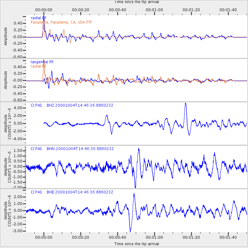
Signal To Noise
| Channel | StoN | STA | LTA |
| CI:PAS: :BHN:20001004T14:46:36.886023Z | 1.6172124 | 3.0143286E-7 | 1.8639041E-7 |
| CI:PAS: :BHE:20001004T14:46:36.886023Z | 2.1450448 | 4.442791E-7 | 2.071188E-7 |
| CI:PAS: :BHZ:20001004T14:46:36.886023Z | 3.746437 | 1.0005417E-6 | 2.6706485E-7 |
| Arrivals |
| Ps | 9.6 SECOND |
| PpPs | 30 SECOND |
| PsPs/PpSs | 40 SECOND |


