You are here: Home > Network List > WY - Yellowstone Wyoming Seismic Network Stations List
> Station YNR Norris Junction, YNP, WY, USA > Earthquake Result Viewer
YNR Norris Junction, YNP, WY, USA - Earthquake Result Viewer
| Earthquake location: |
Southeast Of Honshu, Japan |
| Earthquake latitude/longitude: |
30.8/143.0 |
| Earthquake time(UTC): |
2015/05/30 (150) 18:49:07 GMT |
| Earthquake Depth: |
13 km |
| Earthquake Magnitude: |
6.4 MO |
| Earthquake Catalog/Contributor: |
NEIC PDE/NEIC ALERT |
|
| Network: |
WY Yellowstone Wyoming Seismic Network |
| Station: |
YNR Norris Junction, YNP, WY, USA |
| Lat/Lon: |
44.72 N/110.68 W |
| Elevation: |
2336 m |
|
| Distance: |
79.4 deg |
| Az: |
44.13 deg |
| Baz: |
302.795 deg |
| Ray Param: |
0.049010176 |
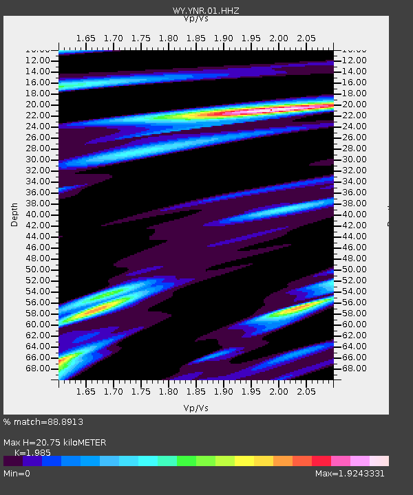
| Estimated Moho Depth: |
20.75 km |
| Estimated Crust Vp/Vs: |
1.99 |
| Assumed Crust Vp: |
6.35 km/s |
| Estimated Crust Vs: |
3.199 km/s |
| Estimated Crust Poisson's Ratio: |
0.33 |
|
| Radial Match: |
88.8913 % |
| Radial Bump: |
400 |
| Transverse Match: |
61.036053 % |
| Transverse Bump: |
400 |
| SOD ConfigId: |
976571 |
| Insert Time: |
2015-06-13 19:24:53.884 +0000 |
| GWidth: |
2.5 |
| Max Bumps: |
400 |
| Tol: |
0.001 |
|

Signal To Noise
| Channel | StoN | STA | LTA |
| WY:YNR:01:HHZ:20150530T19:00:41.794019Z | 4.4915476 | 7.522415E-9 | 1.6747934E-9 |
| WY:YNR:01:HHN:20150530T19:00:41.794019Z | 1.7209218 | 4.3978603E-9 | 2.555526E-9 |
| WY:YNR:01:HHE:20150530T19:00:41.794019Z | 1.0727143 | 2.850755E-9 | 2.6575155E-9 |
| Arrivals |
| Ps | 3.3 SECOND |
| PpPs | 9.5 SECOND |
| PsPs/PpSs | 13 SECOND |


