You are here: Home > Network List > TA - USArray Transportable Network (new EarthScope stations) Stations List
> Station Z41A Richland Creek Farm, El Dorado, AR, USA > Earthquake Result Viewer
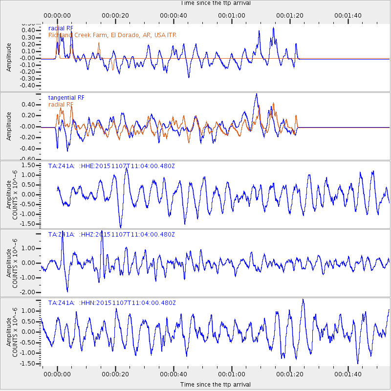
Z41A Richland Creek Farm, El Dorado, AR, USA - Earthquake Result Viewer
*The percent match for this event was below the threshold and hence no stack was calculated.
| Earthquake location: |
Near Coast Of Central Chile |
| Earthquake latitude/longitude: |
-30.7/-71.3 |
| Earthquake time(UTC): |
2015/11/07 (311) 10:53:38 GMT |
| Earthquake Depth: |
3.8 km |
| Earthquake Magnitude: |
5.9 MB |
| Earthquake Catalog/Contributor: |
NEIC PDE/NEIC COMCAT |
|
| Network: |
TA USArray Transportable Network (new EarthScope stations) |
| Station: |
Z41A Richland Creek Farm, El Dorado, AR, USA |
| Lat/Lon: |
33.26 N/92.80 W |
| Elevation: |
62 m |
|
| Distance: |
66.8 deg |
| Az: |
340.513 deg |
| Baz: |
159.952 deg |
| Ray Param: |
$rayparam |
*The percent match for this event was below the threshold and hence was not used in the summary stack. |
|
| Radial Match: |
49.72601 % |
| Radial Bump: |
400 |
| Transverse Match: |
55.373363 % |
| Transverse Bump: |
400 |
| SOD ConfigId: |
7422571 |
| Insert Time: |
2019-04-21 06:43:42.183 +0000 |
| GWidth: |
2.5 |
| Max Bumps: |
400 |
| Tol: |
0.001 |
|
Signal To Noise
| Channel | StoN | STA | LTA |
| TA:Z41A: :HHZ:20151107T11:04:00.480Z | 3.4903579 | 8.939673E-7 | 2.5612482E-7 |
| TA:Z41A: :HHN:20151107T11:04:00.480Z | 0.82524437 | 4.1080432E-7 | 4.977972E-7 |
| TA:Z41A: :HHE:20151107T11:04:00.480Z | 0.82086 | 4.5377348E-7 | 5.5280253E-7 |
| Arrivals |
| Ps | |
| PpPs | |
| PsPs/PpSs | |


