You are here: Home > Network List > TA - USArray Transportable Network (new EarthScope stations) Stations List
> Station MDND Maddock, ND, USA > Earthquake Result Viewer
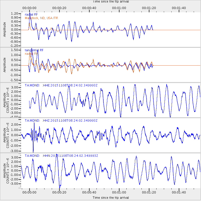
MDND Maddock, ND, USA - Earthquake Result Viewer
*The percent match for this event was below the threshold and hence no stack was calculated.
| Earthquake location: |
Peru-Bolivia Border Region |
| Earthquake latitude/longitude: |
-17.3/-69.5 |
| Earthquake time(UTC): |
2015/11/08 (312) 08:13:36 GMT |
| Earthquake Depth: |
152 km |
| Earthquake Magnitude: |
5.7 MWW, 5.7 MWC, 5.7 MWB |
| Earthquake Catalog/Contributor: |
NEIC PDE/NEIC COMCAT |
|
| Network: |
TA USArray Transportable Network (new EarthScope stations) |
| Station: |
MDND Maddock, ND, USA |
| Lat/Lon: |
47.85 N/99.60 W |
| Elevation: |
479 m |
|
| Distance: |
70.2 deg |
| Az: |
338.953 deg |
| Baz: |
149.374 deg |
| Ray Param: |
$rayparam |
*The percent match for this event was below the threshold and hence was not used in the summary stack. |
|
| Radial Match: |
62.08023 % |
| Radial Bump: |
400 |
| Transverse Match: |
79.9124 % |
| Transverse Bump: |
400 |
| SOD ConfigId: |
7422571 |
| Insert Time: |
2019-04-21 06:57:02.947 +0000 |
| GWidth: |
2.5 |
| Max Bumps: |
400 |
| Tol: |
0.001 |
|
Signal To Noise
| Channel | StoN | STA | LTA |
| TA:MDND: :HHZ:20151108T08:24:02.349993Z | 2.336406 | 1.0425998E-6 | 4.4624088E-7 |
| TA:MDND: :HHN:20151108T08:24:02.349993Z | 1.1075909 | 1.547097E-6 | 1.3968126E-6 |
| TA:MDND: :HHE:20151108T08:24:02.349993Z | 0.6959566 | 9.332269E-7 | 1.3409268E-6 |
| Arrivals |
| Ps | |
| PpPs | |
| PsPs/PpSs | |


