You are here: Home > Network List > TA - USArray Transportable Network (new EarthScope stations) Stations List
> Station N02D Trinity Center, CA, USA > Earthquake Result Viewer
N02D Trinity Center, CA, USA - Earthquake Result Viewer
| Earthquake location: |
Peru-Bolivia Border Region |
| Earthquake latitude/longitude: |
-17.3/-69.5 |
| Earthquake time(UTC): |
2015/11/08 (312) 08:13:36 GMT |
| Earthquake Depth: |
152 km |
| Earthquake Magnitude: |
5.7 MWW, 5.7 MWC, 5.7 MWB |
| Earthquake Catalog/Contributor: |
NEIC PDE/NEIC COMCAT |
|
| Network: |
TA USArray Transportable Network (new EarthScope stations) |
| Station: |
N02D Trinity Center, CA, USA |
| Lat/Lon: |
40.97 N/122.71 W |
| Elevation: |
937 m |
|
| Distance: |
76.1 deg |
| Az: |
321.337 deg |
| Baz: |
127.969 deg |
| Ray Param: |
0.05085315 |
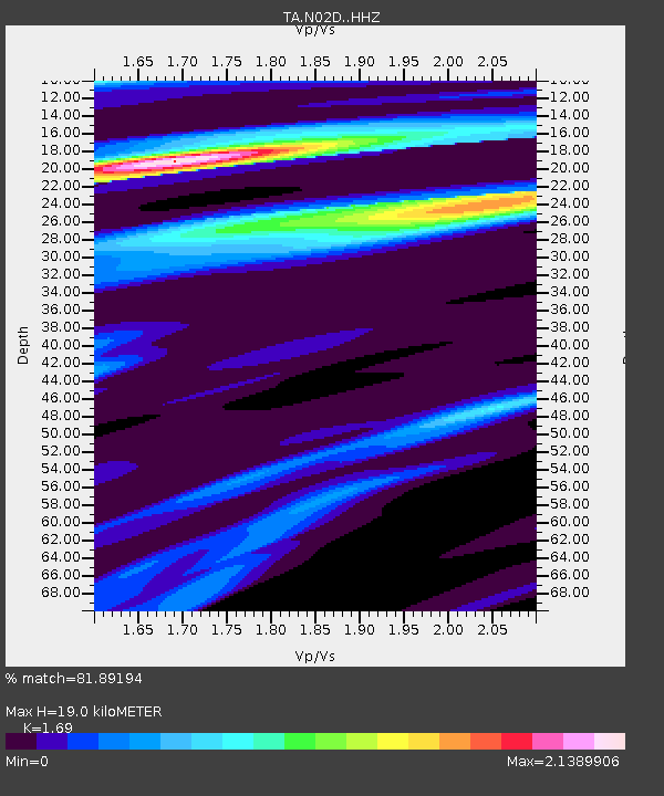
| Estimated Moho Depth: |
19.0 km |
| Estimated Crust Vp/Vs: |
1.69 |
| Assumed Crust Vp: |
6.566 km/s |
| Estimated Crust Vs: |
3.885 km/s |
| Estimated Crust Poisson's Ratio: |
0.23 |
|
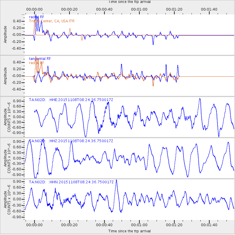
| Radial Match: |
81.89194 % |
| Radial Bump: |
356 |
| Transverse Match: |
76.77333 % |
| Transverse Bump: |
400 |
| SOD ConfigId: |
7422571 |
| Insert Time: |
2019-04-21 06:57:03.662 +0000 |
| GWidth: |
2.5 |
| Max Bumps: |
400 |
| Tol: |
0.001 |
|
Signal To Noise
| Channel | StoN | STA | LTA |
| TA:N02D: :HHZ:20151108T08:24:36.750017Z | 1.5165589 | 7.387407E-7 | 4.871164E-7 |
| TA:N02D: :HHN:20151108T08:24:36.750017Z | 0.81855214 | 2.2331666E-7 | 2.728191E-7 |
| TA:N02D: :HHE:20151108T08:24:36.750017Z | 1.8797885 | 7.477247E-7 | 3.9777063E-7 |
| Arrivals |
| Ps | 2.1 SECOND |
| PpPs | 7.5 SECOND |
| PsPs/PpSs | 9.6 SECOND |


