You are here: Home > Network List > TA - USArray Transportable Network (new EarthScope stations) Stations List
> Station O48A Farmland, IN, USA > Earthquake Result Viewer
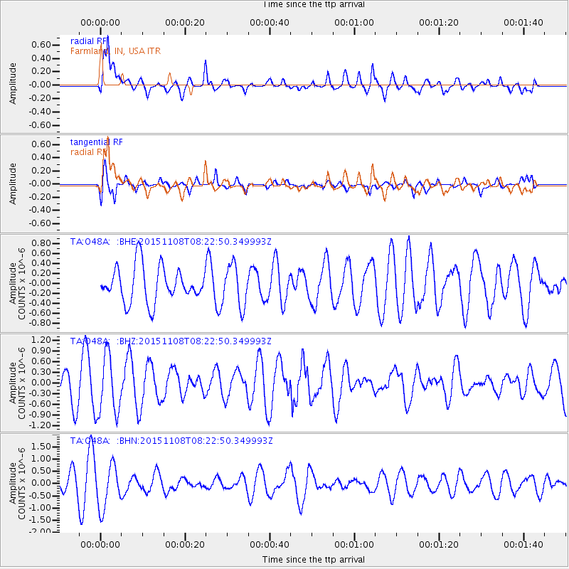
O48A Farmland, IN, USA - Earthquake Result Viewer
*The percent match for this event was below the threshold and hence no stack was calculated.
| Earthquake location: |
Peru-Bolivia Border Region |
| Earthquake latitude/longitude: |
-17.3/-69.5 |
| Earthquake time(UTC): |
2015/11/08 (312) 08:13:36 GMT |
| Earthquake Depth: |
152 km |
| Earthquake Magnitude: |
5.7 MWW, 5.7 MWC, 5.7 MWB |
| Earthquake Catalog/Contributor: |
NEIC PDE/NEIC COMCAT |
|
| Network: |
TA USArray Transportable Network (new EarthScope stations) |
| Station: |
O48A Farmland, IN, USA |
| Lat/Lon: |
40.26 N/85.16 W |
| Elevation: |
300 m |
|
| Distance: |
59.1 deg |
| Az: |
346.061 deg |
| Baz: |
162.497 deg |
| Ray Param: |
$rayparam |
*The percent match for this event was below the threshold and hence was not used in the summary stack. |
|
| Radial Match: |
66.4888 % |
| Radial Bump: |
400 |
| Transverse Match: |
79.731316 % |
| Transverse Bump: |
400 |
| SOD ConfigId: |
7422571 |
| Insert Time: |
2019-04-21 06:57:05.868 +0000 |
| GWidth: |
2.5 |
| Max Bumps: |
400 |
| Tol: |
0.001 |
|
Signal To Noise
| Channel | StoN | STA | LTA |
| TA:O48A: :BHZ:20151108T08:22:50.349993Z | 1.4675376 | 8.228316E-7 | 5.606886E-7 |
| TA:O48A: :BHN:20151108T08:22:50.349993Z | 1.8604652 | 8.94657E-7 | 4.808781E-7 |
| TA:O48A: :BHE:20151108T08:22:50.349993Z | 1.20624 | 4.2051E-7 | 3.486122E-7 |
| Arrivals |
| Ps | |
| PpPs | |
| PsPs/PpSs | |


