You are here: Home > Network List > AF - Africa Array Stations List
> Station TEBE Entebbe, Uganda > Earthquake Result Viewer
TEBE Entebbe, Uganda - Earthquake Result Viewer
| Earthquake location: |
Northern Sumatra, Indonesia |
| Earthquake latitude/longitude: |
0.7/98.9 |
| Earthquake time(UTC): |
2015/11/08 (312) 09:34:57 GMT |
| Earthquake Depth: |
75 km |
| Earthquake Magnitude: |
6.1 MB |
| Earthquake Catalog/Contributor: |
NEIC PDE/NEIC COMCAT |
|
| Network: |
AF Africa Array |
| Station: |
TEBE Entebbe, Uganda |
| Lat/Lon: |
0.05 N/32.48 E |
| Elevation: |
1132 m |
|
| Distance: |
66.4 deg |
| Az: |
269.736 deg |
| Baz: |
89.218 deg |
| Ray Param: |
0.057461143 |
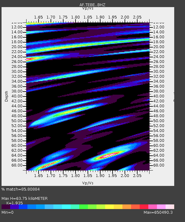
| Estimated Moho Depth: |
63.75 km |
| Estimated Crust Vp/Vs: |
1.93 |
| Assumed Crust Vp: |
6.642 km/s |
| Estimated Crust Vs: |
3.432 km/s |
| Estimated Crust Poisson's Ratio: |
0.32 |
|
| Radial Match: |
85.80884 % |
| Radial Bump: |
400 |
| Transverse Match: |
85.80881 % |
| Transverse Bump: |
400 |
| SOD ConfigId: |
7422571 |
| Insert Time: |
2019-04-21 06:59:36.172 +0000 |
| GWidth: |
2.5 |
| Max Bumps: |
400 |
| Tol: |
0.001 |
|

Signal To Noise
| Channel | StoN | STA | LTA |
| AF:TEBE: :BHZ:20151108T09:45:08.339976Z | 12.954131 | 1.1719017E-12 | 9.046547E-14 |
| AF:TEBE: :BHN:20151108T09:45:08.339976Z | 2.8875835 | 1.690948E-13 | 5.855928E-14 |
| AF:TEBE: :BHE:20151108T09:45:08.339976Z | 6.5552864 | 8.048875E-7 | 1.227845E-7 |
| Arrivals |
| Ps | 9.3 SECOND |
| PpPs | 27 SECOND |
| PsPs/PpSs | 36 SECOND |


