You are here: Home > Network List > TA - USArray Transportable Network (new EarthScope stations) Stations List
> Station A21K Barrow, AK, USA > Earthquake Result Viewer
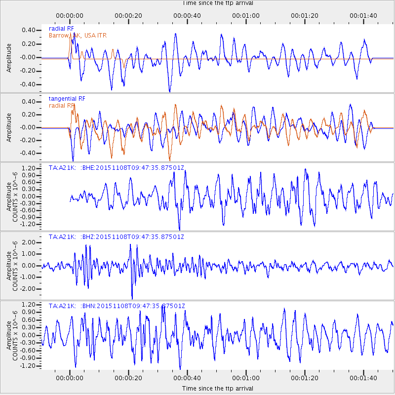
A21K Barrow, AK, USA - Earthquake Result Viewer
*The percent match for this event was below the threshold and hence no stack was calculated.
| Earthquake location: |
Northern Sumatra, Indonesia |
| Earthquake latitude/longitude: |
0.7/98.9 |
| Earthquake time(UTC): |
2015/11/08 (312) 09:34:57 GMT |
| Earthquake Depth: |
75 km |
| Earthquake Magnitude: |
6.1 MB |
| Earthquake Catalog/Contributor: |
NEIC PDE/NEIC COMCAT |
|
| Network: |
TA USArray Transportable Network (new EarthScope stations) |
| Station: |
A21K Barrow, AK, USA |
| Lat/Lon: |
71.32 N/156.62 W |
| Elevation: |
577 m |
|
| Distance: |
93.9 deg |
| Az: |
18.219 deg |
| Baz: |
283.995 deg |
| Ray Param: |
$rayparam |
*The percent match for this event was below the threshold and hence was not used in the summary stack. |
|
| Radial Match: |
64.11041 % |
| Radial Bump: |
400 |
| Transverse Match: |
53.31776 % |
| Transverse Bump: |
400 |
| SOD ConfigId: |
7422571 |
| Insert Time: |
2019-04-21 07:02:51.151 +0000 |
| GWidth: |
2.5 |
| Max Bumps: |
400 |
| Tol: |
0.001 |
|
Signal To Noise
| Channel | StoN | STA | LTA |
| TA:A21K: :BHZ:20151108T09:47:35.87501Z | 3.5132115 | 6.1003107E-7 | 1.7363915E-7 |
| TA:A21K: :BHN:20151108T09:47:35.87501Z | 1.3517585 | 5.44498E-7 | 4.0280716E-7 |
| TA:A21K: :BHE:20151108T09:47:35.87501Z | 1.3928471 | 4.0637235E-7 | 2.917566E-7 |
| Arrivals |
| Ps | |
| PpPs | |
| PsPs/PpSs | |


