You are here: Home > Network List > XL12 - Hangay Dome, Mongolia Stations List
> Station AT13 AT13 > Earthquake Result Viewer
AT13 AT13 - Earthquake Result Viewer
| Earthquake location: |
Northern Sumatra, Indonesia |
| Earthquake latitude/longitude: |
0.7/98.9 |
| Earthquake time(UTC): |
2015/11/08 (312) 09:34:57 GMT |
| Earthquake Depth: |
75 km |
| Earthquake Magnitude: |
6.1 MB |
| Earthquake Catalog/Contributor: |
NEIC PDE/NEIC COMCAT |
|
| Network: |
XL Hangay Dome, Mongolia |
| Station: |
AT13 AT13 |
| Lat/Lon: |
44.99 N/96.27 E |
| Elevation: |
1091 m |
|
| Distance: |
44.1 deg |
| Az: |
357.345 deg |
| Baz: |
176.257 deg |
| Ray Param: |
0.07188029 |
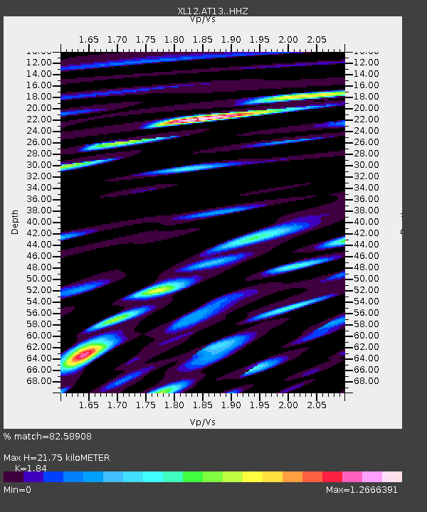
| Estimated Moho Depth: |
21.75 km |
| Estimated Crust Vp/Vs: |
1.84 |
| Assumed Crust Vp: |
6.353 km/s |
| Estimated Crust Vs: |
3.453 km/s |
| Estimated Crust Poisson's Ratio: |
0.29 |
|
| Radial Match: |
82.58908 % |
| Radial Bump: |
400 |
| Transverse Match: |
63.5805 % |
| Transverse Bump: |
400 |
| SOD ConfigId: |
7422571 |
| Insert Time: |
2019-04-21 07:03:14.981 +0000 |
| GWidth: |
2.5 |
| Max Bumps: |
400 |
| Tol: |
0.001 |
|

Signal To Noise
| Channel | StoN | STA | LTA |
| XL:AT13: :HHZ:20151108T09:42:28.079996Z | 27.484146 | 1.5385269E-6 | 5.5978706E-8 |
| XL:AT13: :HHN:20151108T09:42:28.079996Z | 13.960261 | 1.4405726E-6 | 1.0319095E-7 |
| XL:AT13: :HHE:20151108T09:42:28.079996Z | 3.0012057 | 4.949672E-7 | 1.6492278E-7 |
| Arrivals |
| Ps | 3.1 SECOND |
| PpPs | 9.1 SECOND |
| PsPs/PpSs | 12 SECOND |


