You are here: Home > Network List > IU - Global Seismograph Network (GSN - IRIS/USGS) Stations List
> Station JOHN Johnston Island, USA > Earthquake Result Viewer
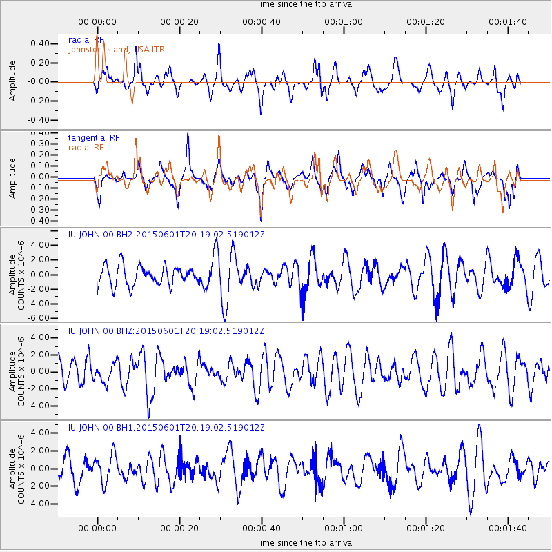
JOHN Johnston Island, USA - Earthquake Result Viewer
*The percent match for this event was below the threshold and hence no stack was calculated.
| Earthquake location: |
Off Coast Of Oregon |
| Earthquake latitude/longitude: |
44.5/-129.9 |
| Earthquake time(UTC): |
2015/06/01 (152) 20:11:31 GMT |
| Earthquake Depth: |
10 km |
| Earthquake Magnitude: |
5.9 MO |
| Earthquake Catalog/Contributor: |
NEIC PDE/NEIC ALERT |
|
| Network: |
IU Global Seismograph Network (GSN - IRIS/USGS) |
| Station: |
JOHN Johnston Island, USA |
| Lat/Lon: |
16.73 N/169.53 W |
| Elevation: |
2.0 m |
|
| Distance: |
43.3 deg |
| Az: |
243.114 deg |
| Baz: |
41.779 deg |
| Ray Param: |
$rayparam |
*The percent match for this event was below the threshold and hence was not used in the summary stack. |
|
| Radial Match: |
52.484673 % |
| Radial Bump: |
379 |
| Transverse Match: |
54.5281 % |
| Transverse Bump: |
355 |
| SOD ConfigId: |
976571 |
| Insert Time: |
2015-06-15 20:42:20.299 +0000 |
| GWidth: |
2.5 |
| Max Bumps: |
400 |
| Tol: |
0.001 |
|
Signal To Noise
| Channel | StoN | STA | LTA |
| IU:JOHN:00:BHZ:20150601T20:19:02.519012Z | 0.8303815 | 1.0846464E-6 | 1.3062025E-6 |
| IU:JOHN:00:BH1:20150601T20:19:02.519012Z | 0.81298137 | 1.6146525E-6 | 1.986088E-6 |
| IU:JOHN:00:BH2:20150601T20:19:02.519012Z | 2.7846026 | 3.665822E-6 | 1.3164614E-6 |
| Arrivals |
| Ps | |
| PpPs | |
| PsPs/PpSs | |


