You are here: Home > Network List > CB - China National Seismic Network Stations List
> Station WHN Wuhantai,Hubei Province > Earthquake Result Viewer
WHN Wuhantai,Hubei Province - Earthquake Result Viewer
| Earthquake location: |
Nicobar Islands, India Region |
| Earthquake latitude/longitude: |
6.8/94.7 |
| Earthquake time(UTC): |
2015/11/08 (312) 16:47:01 GMT |
| Earthquake Depth: |
7.7 km |
| Earthquake Magnitude: |
6.4 MWB |
| Earthquake Catalog/Contributor: |
NEIC PDE/NEIC COMCAT |
|
| Network: |
CB China National Seismic Network |
| Station: |
WHN Wuhantai,Hubei Province |
| Lat/Lon: |
30.54 N/114.35 E |
| Elevation: |
80 m |
|
| Distance: |
29.9 deg |
| Az: |
35.523 deg |
| Baz: |
221.97 deg |
| Ray Param: |
0.079470456 |
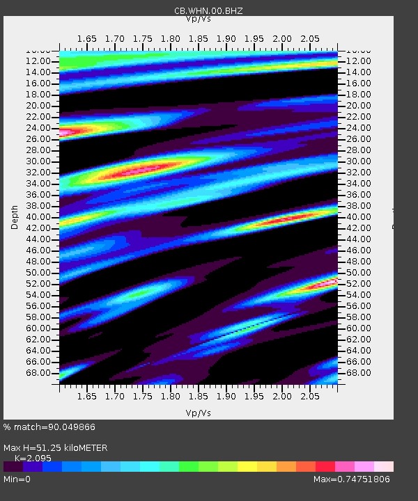
| Estimated Moho Depth: |
51.25 km |
| Estimated Crust Vp/Vs: |
2.10 |
| Assumed Crust Vp: |
6.276 km/s |
| Estimated Crust Vs: |
2.996 km/s |
| Estimated Crust Poisson's Ratio: |
0.35 |
|
| Radial Match: |
90.049866 % |
| Radial Bump: |
400 |
| Transverse Match: |
76.97153 % |
| Transverse Bump: |
400 |
| SOD ConfigId: |
7422571 |
| Insert Time: |
2019-04-21 07:31:19.615 +0000 |
| GWidth: |
2.5 |
| Max Bumps: |
400 |
| Tol: |
0.001 |
|

Signal To Noise
| Channel | StoN | STA | LTA |
| CB:WHN:00:BHZ:20151108T16:52:39.879999Z | 5.333203 | 6.341469E-7 | 1.1890545E-7 |
| CB:WHN:00:BHN:20151108T16:52:39.879999Z | 1.7604303 | 2.925013E-7 | 1.661533E-7 |
| CB:WHN:00:BHE:20151108T16:52:39.879999Z | 2.1549945 | 2.9264896E-7 | 1.3580033E-7 |
| Arrivals |
| Ps | 9.5 SECOND |
| PpPs | 24 SECOND |
| PsPs/PpSs | 33 SECOND |


