You are here: Home > Network List > NE - New England Seismic Network Stations List
> Station EMMW Machias, ME, USA > Earthquake Result Viewer
EMMW Machias, ME, USA - Earthquake Result Viewer
*The percent match for this event was below the threshold and hence no stack was calculated.
| Earthquake location: |
Off Coast Of Oregon |
| Earthquake latitude/longitude: |
44.5/-129.9 |
| Earthquake time(UTC): |
2015/06/01 (152) 20:11:31 GMT |
| Earthquake Depth: |
10 km |
| Earthquake Magnitude: |
5.9 MO |
| Earthquake Catalog/Contributor: |
NEIC PDE/NEIC ALERT |
|
| Network: |
NE New England Seismic Network |
| Station: |
EMMW Machias, ME, USA |
| Lat/Lon: |
44.71 N/67.46 W |
| Elevation: |
35 m |
|
| Distance: |
43.4 deg |
| Az: |
66.781 deg |
| Baz: |
292.708 deg |
| Ray Param: |
$rayparam |
*The percent match for this event was below the threshold and hence was not used in the summary stack. |
|
| Radial Match: |
73.91594 % |
| Radial Bump: |
400 |
| Transverse Match: |
54.155666 % |
| Transverse Bump: |
400 |
| SOD ConfigId: |
976571 |
| Insert Time: |
2015-06-15 20:43:41.370 +0000 |
| GWidth: |
2.5 |
| Max Bumps: |
400 |
| Tol: |
0.001 |
|
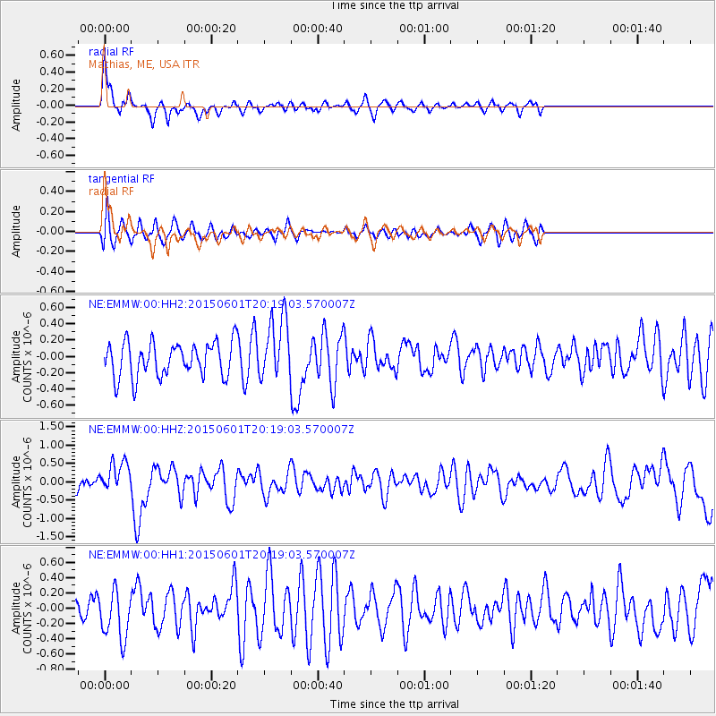
Signal To Noise
| Channel | StoN | STA | LTA |
| NE:EMMW:00:HHZ:20150601T20:19:03.570007Z | 1.2856444 | 4.220256E-7 | 3.2825997E-7 |
| NE:EMMW:00:HH1:20150601T20:19:03.570007Z | 1.2309186 | 3.1825522E-7 | 2.5855098E-7 |
| NE:EMMW:00:HH2:20150601T20:19:03.570007Z | 1.849303 | 3.863122E-7 | 2.0889611E-7 |
| Arrivals |
| Ps | |
| PpPs | |
| PsPs/PpSs | |


