You are here: Home > Network List > CI - Caltech Regional Seismic Network Stations List
> Station PAS Pasadena, Pasadena, CA, USA > Earthquake Result Viewer
PAS Pasadena, Pasadena, CA, USA - Earthquake Result Viewer
| Earthquake location: |
Kodiak Island Region, Alaska |
| Earthquake latitude/longitude: |
57.2/-151.0 |
| Earthquake time(UTC): |
2001/07/19 (200) 18:00:40 GMT |
| Earthquake Depth: |
33 km |
| Earthquake Magnitude: |
5.9 MB, 5.4 MS, 5.9 MW, 5.9 ML |
| Earthquake Catalog/Contributor: |
WHDF/NEIC |
|
| Network: |
CI Caltech Regional Seismic Network |
| Station: |
PAS Pasadena, Pasadena, CA, USA |
| Lat/Lon: |
34.15 N/118.17 W |
| Elevation: |
314 m |
|
| Distance: |
32.0 deg |
| Az: |
121.916 deg |
| Baz: |
326.15 deg |
| Ray Param: |
0.0787803 |
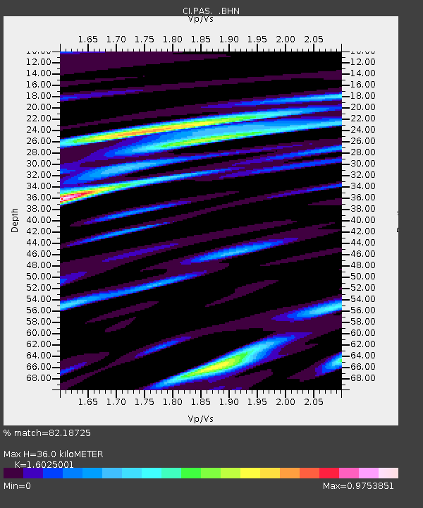
| Estimated Moho Depth: |
36.0 km |
| Estimated Crust Vp/Vs: |
1.60 |
| Assumed Crust Vp: |
6.1 km/s |
| Estimated Crust Vs: |
3.807 km/s |
| Estimated Crust Poisson's Ratio: |
0.18 |
|
| Radial Match: |
82.18725 % |
| Radial Bump: |
400 |
| Transverse Match: |
78.93732 % |
| Transverse Bump: |
400 |
| SOD ConfigId: |
3770 |
| Insert Time: |
2010-02-25 23:54:38.470 +0000 |
| GWidth: |
2.5 |
| Max Bumps: |
400 |
| Tol: |
0.001 |
|
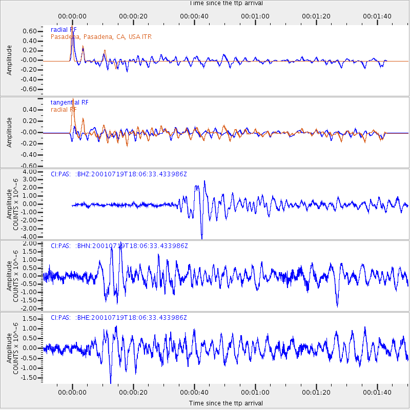
Signal To Noise
| Channel | StoN | STA | LTA |
| CI:PAS: :BHN:20010719T18:06:33.433986Z | 0.85070354 | 1.4921724E-7 | 1.7540451E-7 |
| CI:PAS: :BHE:20010719T18:06:33.433986Z | 1.1702721 | 1.6031649E-7 | 1.3699078E-7 |
| CI:PAS: :BHZ:20010719T18:06:33.433986Z | 1.1535418 | 1.3589286E-7 | 1.1780489E-7 |
| Arrivals |
| Ps | 3.8 SECOND |
| PpPs | 14 SECOND |
| PsPs/PpSs | 18 SECOND |


