You are here: Home > Network List > NI - North-East Italy Broadband Network Stations List
> Station DRE Drenchia > Earthquake Result Viewer
DRE Drenchia - Earthquake Result Viewer
| Earthquake location: |
Nicobar Islands, India Region |
| Earthquake latitude/longitude: |
6.8/94.7 |
| Earthquake time(UTC): |
2015/11/08 (312) 16:47:01 GMT |
| Earthquake Depth: |
7.7 km |
| Earthquake Magnitude: |
6.4 MWB |
| Earthquake Catalog/Contributor: |
NEIC PDE/NEIC COMCAT |
|
| Network: |
NI North-East Italy Broadband Network |
| Station: |
DRE Drenchia |
| Lat/Lon: |
46.17 N/13.65 E |
| Elevation: |
810 m |
|
| Distance: |
78.9 deg |
| Az: |
315.612 deg |
| Baz: |
91.666 deg |
| Ray Param: |
0.04931432 |
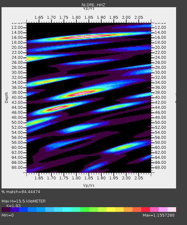
| Estimated Moho Depth: |
15.5 km |
| Estimated Crust Vp/Vs: |
1.83 |
| Assumed Crust Vp: |
6.35 km/s |
| Estimated Crust Vs: |
3.47 km/s |
| Estimated Crust Poisson's Ratio: |
0.29 |
|
| Radial Match: |
94.44474 % |
| Radial Bump: |
400 |
| Transverse Match: |
87.65955 % |
| Transverse Bump: |
400 |
| SOD ConfigId: |
7422571 |
| Insert Time: |
2019-04-21 07:32:57.294 +0000 |
| GWidth: |
2.5 |
| Max Bumps: |
400 |
| Tol: |
0.001 |
|

Signal To Noise
| Channel | StoN | STA | LTA |
| NI:DRE: :HHZ:20151108T16:58:34.047998Z | 4.8766356 | 6.9277434E-7 | 1.4205989E-7 |
| NI:DRE: :HHN:20151108T16:58:34.047998Z | 1.2875143 | 2.1972404E-7 | 1.7065754E-7 |
| NI:DRE: :HHE:20151108T16:58:34.047998Z | 3.4539223 | 3.2675362E-7 | 9.460364E-8 |
| Arrivals |
| Ps | 2.1 SECOND |
| PpPs | 6.7 SECOND |
| PsPs/PpSs | 8.8 SECOND |


