You are here: Home > Network List > TJ - Tajikistan National Seismic Network Stations List
> Station SHAA Shaartuz, Tajikistan > Earthquake Result Viewer
SHAA Shaartuz, Tajikistan - Earthquake Result Viewer
| Earthquake location: |
Nicobar Islands, India Region |
| Earthquake latitude/longitude: |
6.8/94.7 |
| Earthquake time(UTC): |
2015/11/08 (312) 16:47:01 GMT |
| Earthquake Depth: |
7.7 km |
| Earthquake Magnitude: |
6.4 MWB |
| Earthquake Catalog/Contributor: |
NEIC PDE/NEIC COMCAT |
|
| Network: |
TJ Tajikistan National Seismic Network |
| Station: |
SHAA Shaartuz, Tajikistan |
| Lat/Lon: |
37.56 N/68.12 E |
| Elevation: |
868 m |
|
| Distance: |
39.0 deg |
| Az: |
325.551 deg |
| Baz: |
135.022 deg |
| Ray Param: |
0.075254425 |
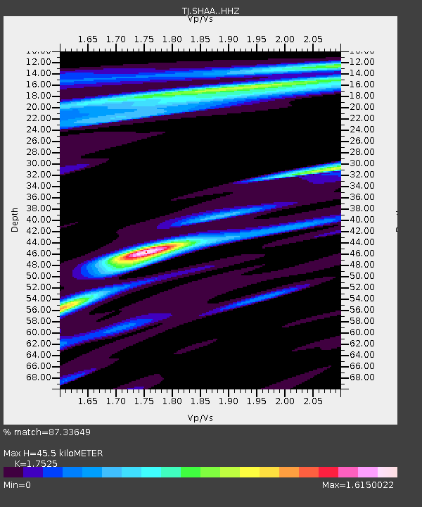
| Estimated Moho Depth: |
45.5 km |
| Estimated Crust Vp/Vs: |
1.75 |
| Assumed Crust Vp: |
6.213 km/s |
| Estimated Crust Vs: |
3.545 km/s |
| Estimated Crust Poisson's Ratio: |
0.26 |
|
| Radial Match: |
87.33649 % |
| Radial Bump: |
400 |
| Transverse Match: |
72.90495 % |
| Transverse Bump: |
400 |
| SOD ConfigId: |
7422571 |
| Insert Time: |
2019-04-21 07:33:47.331 +0000 |
| GWidth: |
2.5 |
| Max Bumps: |
400 |
| Tol: |
0.001 |
|
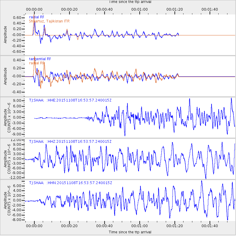
Signal To Noise
| Channel | StoN | STA | LTA |
| TJ:SHAA: :HHZ:20151108T16:53:57.240015Z | 12.907467 | 2.6686216E-6 | 2.0675023E-7 |
| TJ:SHAA: :HHN:20151108T16:53:57.240015Z | 2.2631588 | 3.4311145E-7 | 1.5160732E-7 |
| TJ:SHAA: :HHE:20151108T16:53:57.240015Z | 8.2223625 | 1.048245E-6 | 1.274871E-7 |
| Arrivals |
| Ps | 5.9 SECOND |
| PpPs | 19 SECOND |
| PsPs/PpSs | 25 SECOND |


