You are here: Home > Network List > XL12 - Hangay Dome, Mongolia Stations List
> Station HV19 HV19 > Earthquake Result Viewer
HV19 HV19 - Earthquake Result Viewer
| Earthquake location: |
Nicobar Islands, India Region |
| Earthquake latitude/longitude: |
6.8/94.7 |
| Earthquake time(UTC): |
2015/11/08 (312) 16:47:01 GMT |
| Earthquake Depth: |
7.7 km |
| Earthquake Magnitude: |
6.4 MWB |
| Earthquake Catalog/Contributor: |
NEIC PDE/NEIC COMCAT |
|
| Network: |
XL Hangay Dome, Mongolia |
| Station: |
HV19 HV19 |
| Lat/Lon: |
50.98 N/100.73 E |
| Elevation: |
1683 m |
|
| Distance: |
44.3 deg |
| Az: |
5.435 deg |
| Baz: |
188.556 deg |
| Ray Param: |
0.072016954 |
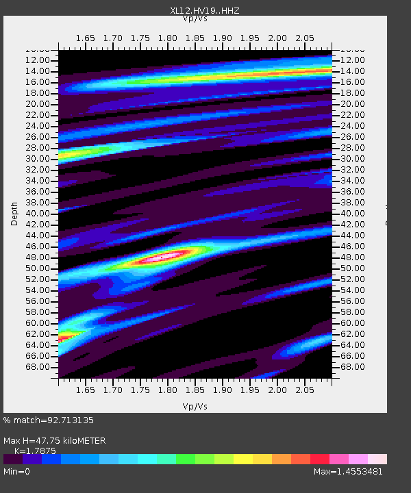
| Estimated Moho Depth: |
47.75 km |
| Estimated Crust Vp/Vs: |
1.79 |
| Assumed Crust Vp: |
6.419 km/s |
| Estimated Crust Vs: |
3.591 km/s |
| Estimated Crust Poisson's Ratio: |
0.27 |
|
| Radial Match: |
92.713135 % |
| Radial Bump: |
400 |
| Transverse Match: |
70.655304 % |
| Transverse Bump: |
400 |
| SOD ConfigId: |
7422571 |
| Insert Time: |
2019-04-21 07:34:19.650 +0000 |
| GWidth: |
2.5 |
| Max Bumps: |
400 |
| Tol: |
0.001 |
|

Signal To Noise
| Channel | StoN | STA | LTA |
| XL:HV19: :HHZ:20151108T16:54:41.040002Z | 4.4575095 | 3.3754637E-7 | 7.572533E-8 |
| XL:HV19: :HHN:20151108T16:54:41.040002Z | 4.502858 | 3.8227319E-7 | 8.4895674E-8 |
| XL:HV19: :HHE:20151108T16:54:41.040002Z | 1.2458184 | 1.9757246E-7 | 1.5858849E-7 |
| Arrivals |
| Ps | 6.2 SECOND |
| PpPs | 19 SECOND |
| PsPs/PpSs | 26 SECOND |


