You are here: Home > Network List > 7A - Mid-Atlantic Geophysical Integrative Collaboration Stations List
> Station KENT Kenton, Ohio USA > Earthquake Result Viewer
KENT Kenton, Ohio USA - Earthquake Result Viewer
| Earthquake location: |
Andreanof Islands, Aleutian Is. |
| Earthquake latitude/longitude: |
51.7/-173.1 |
| Earthquake time(UTC): |
2015/11/09 (313) 16:03:45 GMT |
| Earthquake Depth: |
10 km |
| Earthquake Magnitude: |
6.2 MWB, 6.3 MI |
| Earthquake Catalog/Contributor: |
NEIC PDE/NEIC COMCAT |
|
| Network: |
7A Mid-Atlantic Geophysical Integrative Collaboration |
| Station: |
KENT Kenton, Ohio USA |
| Lat/Lon: |
40.63 N/83.64 W |
| Elevation: |
296 m |
|
| Distance: |
59.2 deg |
| Az: |
62.428 deg |
| Baz: |
313.595 deg |
| Ray Param: |
0.062372413 |
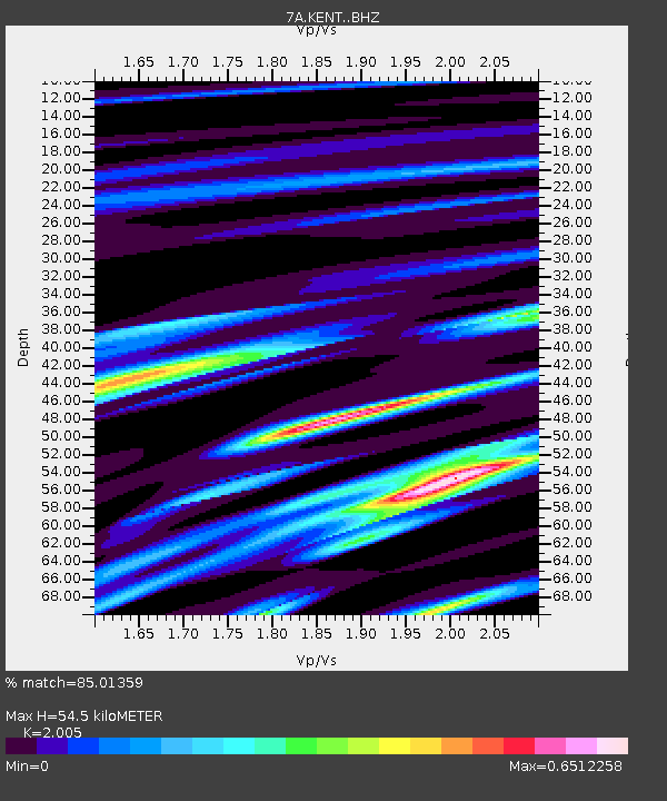
| Estimated Moho Depth: |
54.5 km |
| Estimated Crust Vp/Vs: |
2.01 |
| Assumed Crust Vp: |
6.498 km/s |
| Estimated Crust Vs: |
3.241 km/s |
| Estimated Crust Poisson's Ratio: |
0.33 |
|
| Radial Match: |
85.01359 % |
| Radial Bump: |
328 |
| Transverse Match: |
78.69126 % |
| Transverse Bump: |
400 |
| SOD ConfigId: |
7422571 |
| Insert Time: |
2019-04-21 07:43:34.357 +0000 |
| GWidth: |
2.5 |
| Max Bumps: |
400 |
| Tol: |
0.001 |
|

Signal To Noise
| Channel | StoN | STA | LTA |
| 7A:KENT: :BHZ:20151109T16:13:15.384988Z | 3.4640844 | 9.1948505E-7 | 2.6543378E-7 |
| 7A:KENT: :BHN:20151109T16:13:15.384988Z | 1.8143799 | 3.608597E-7 | 1.9888871E-7 |
| 7A:KENT: :BHE:20151109T16:13:15.384988Z | 2.0994341 | 4.327284E-7 | 2.0611667E-7 |
| Arrivals |
| Ps | 8.8 SECOND |
| PpPs | 24 SECOND |
| PsPs/PpSs | 33 SECOND |


