You are here: Home > Network List > 7A - Mid-Atlantic Geophysical Integrative Collaboration Stations List
> Station WLFT Gordonsville, Virginia USA > Earthquake Result Viewer
WLFT Gordonsville, Virginia USA - Earthquake Result Viewer
| Earthquake location: |
Andreanof Islands, Aleutian Is. |
| Earthquake latitude/longitude: |
51.7/-173.1 |
| Earthquake time(UTC): |
2015/11/09 (313) 16:03:45 GMT |
| Earthquake Depth: |
10 km |
| Earthquake Magnitude: |
6.2 MWB, 6.3 MI |
| Earthquake Catalog/Contributor: |
NEIC PDE/NEIC COMCAT |
|
| Network: |
7A Mid-Atlantic Geophysical Integrative Collaboration |
| Station: |
WLFT Gordonsville, Virginia USA |
| Lat/Lon: |
38.17 N/78.14 W |
| Elevation: |
110 m |
|
| Distance: |
63.9 deg |
| Az: |
60.982 deg |
| Baz: |
316.379 deg |
| Ray Param: |
0.059271134 |
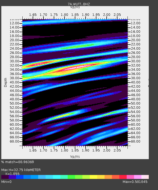
| Estimated Moho Depth: |
32.75 km |
| Estimated Crust Vp/Vs: |
1.86 |
| Assumed Crust Vp: |
6.159 km/s |
| Estimated Crust Vs: |
3.32 km/s |
| Estimated Crust Poisson's Ratio: |
0.30 |
|
| Radial Match: |
88.96369 % |
| Radial Bump: |
379 |
| Transverse Match: |
72.015755 % |
| Transverse Bump: |
400 |
| SOD ConfigId: |
7422571 |
| Insert Time: |
2019-04-21 07:43:42.577 +0000 |
| GWidth: |
2.5 |
| Max Bumps: |
400 |
| Tol: |
0.001 |
|

Signal To Noise
| Channel | StoN | STA | LTA |
| 7A:WLFT: :BHZ:20151109T16:13:47.350015Z | 4.751093 | 1.1911221E-6 | 2.507049E-7 |
| 7A:WLFT: :BHN:20151109T16:13:47.350015Z | 2.4994817 | 6.02086E-7 | 2.4088436E-7 |
| 7A:WLFT: :BHE:20151109T16:13:47.350015Z | 1.2286475 | 3.1337535E-7 | 2.5505716E-7 |
| Arrivals |
| Ps | 4.7 SECOND |
| PpPs | 15 SECOND |
| PsPs/PpSs | 19 SECOND |


