You are here: Home > Network List > 7A - Mid-Atlantic Geophysical Integrative Collaboration Stations List
> Station WTMN Standardsville, Virginia USA > Earthquake Result Viewer
WTMN Standardsville, Virginia USA - Earthquake Result Viewer
| Earthquake location: |
Andreanof Islands, Aleutian Is. |
| Earthquake latitude/longitude: |
51.7/-173.1 |
| Earthquake time(UTC): |
2015/11/09 (313) 16:03:45 GMT |
| Earthquake Depth: |
10 km |
| Earthquake Magnitude: |
6.2 MWB, 6.3 MI |
| Earthquake Catalog/Contributor: |
NEIC PDE/NEIC COMCAT |
|
| Network: |
7A Mid-Atlantic Geophysical Integrative Collaboration |
| Station: |
WTMN Standardsville, Virginia USA |
| Lat/Lon: |
38.30 N/78.48 W |
| Elevation: |
178 m |
|
| Distance: |
63.6 deg |
| Az: |
61.093 deg |
| Baz: |
316.223 deg |
| Ray Param: |
0.059452806 |
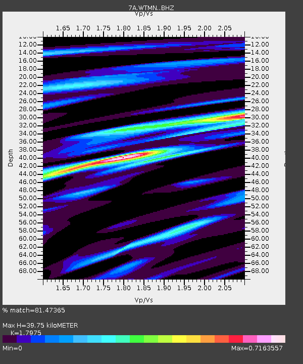
| Estimated Moho Depth: |
39.75 km |
| Estimated Crust Vp/Vs: |
1.80 |
| Assumed Crust Vp: |
6.159 km/s |
| Estimated Crust Vs: |
3.426 km/s |
| Estimated Crust Poisson's Ratio: |
0.28 |
|
| Radial Match: |
81.47365 % |
| Radial Bump: |
400 |
| Transverse Match: |
60.06711 % |
| Transverse Bump: |
400 |
| SOD ConfigId: |
7422571 |
| Insert Time: |
2019-04-21 07:43:43.168 +0000 |
| GWidth: |
2.5 |
| Max Bumps: |
400 |
| Tol: |
0.001 |
|

Signal To Noise
| Channel | StoN | STA | LTA |
| 7A:WTMN: :BHZ:20151109T16:13:45.550027Z | 2.6650712 | 7.95339E-7 | 2.984307E-7 |
| 7A:WTMN: :BHN:20151109T16:13:45.550027Z | 2.0491467 | 4.5275948E-7 | 2.2095026E-7 |
| 7A:WTMN: :BHE:20151109T16:13:45.550027Z | 1.3344871 | 2.570461E-7 | 1.926179E-7 |
| Arrivals |
| Ps | 5.4 SECOND |
| PpPs | 17 SECOND |
| PsPs/PpSs | 23 SECOND |


