You are here: Home > Network List > CB - China National Seismic Network Stations List
> Station HEH Heihe,Heilongjiang Province > Earthquake Result Viewer
HEH Heihe,Heilongjiang Province - Earthquake Result Viewer
| Earthquake location: |
Andreanof Islands, Aleutian Is. |
| Earthquake latitude/longitude: |
51.7/-173.1 |
| Earthquake time(UTC): |
2015/11/09 (313) 16:03:45 GMT |
| Earthquake Depth: |
10 km |
| Earthquake Magnitude: |
6.2 MWB, 6.3 MI |
| Earthquake Catalog/Contributor: |
NEIC PDE/NEIC COMCAT |
|
| Network: |
CB China National Seismic Network |
| Station: |
HEH Heihe,Heilongjiang Province |
| Lat/Lon: |
50.25 N/127.41 E |
| Elevation: |
165 m |
|
| Distance: |
36.6 deg |
| Az: |
291.85 deg |
| Baz: |
64.044 deg |
| Ray Param: |
0.07659843 |
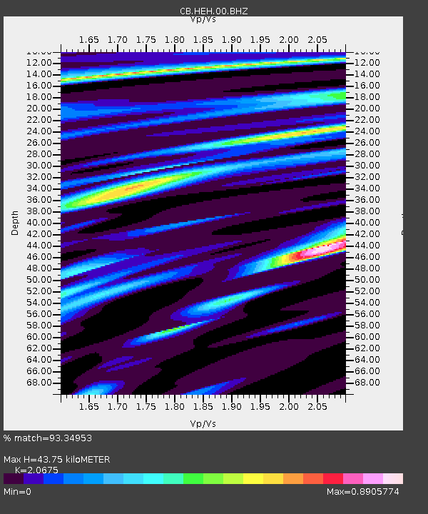
| Estimated Moho Depth: |
43.75 km |
| Estimated Crust Vp/Vs: |
2.07 |
| Assumed Crust Vp: |
6.419 km/s |
| Estimated Crust Vs: |
3.105 km/s |
| Estimated Crust Poisson's Ratio: |
0.35 |
|
| Radial Match: |
93.34953 % |
| Radial Bump: |
257 |
| Transverse Match: |
50.514637 % |
| Transverse Bump: |
400 |
| SOD ConfigId: |
7422571 |
| Insert Time: |
2019-04-21 07:44:26.743 +0000 |
| GWidth: |
2.5 |
| Max Bumps: |
400 |
| Tol: |
0.001 |
|
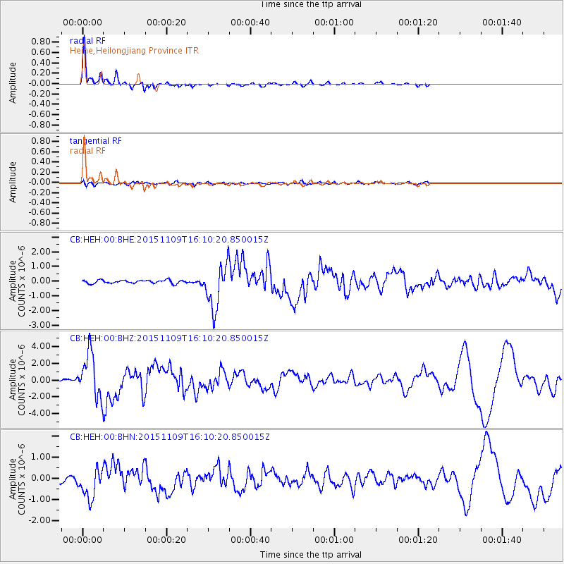
Signal To Noise
| Channel | StoN | STA | LTA |
| CB:HEH:00:BHZ:20151109T16:10:20.850015Z | 28.376848 | 2.665109E-6 | 9.391842E-8 |
| CB:HEH:00:BHN:20151109T16:10:20.850015Z | 5.526124 | 6.8712365E-7 | 1.2434097E-7 |
| CB:HEH:00:BHE:20151109T16:10:20.850015Z | 12.949611 | 1.4282411E-6 | 1.10292206E-7 |
| Arrivals |
| Ps | 7.8 SECOND |
| PpPs | 20 SECOND |
| PsPs/PpSs | 27 SECOND |


