You are here: Home > Network List > IC - New China Digital Seismograph Network Stations List
> Station ENH Enshi, Hubei Province, China > Earthquake Result Viewer
ENH Enshi, Hubei Province, China - Earthquake Result Viewer

| Earthquake location: |
Banda Sea |
| Earthquake latitude/longitude: |
-6.9/128.9 |
| Earthquake time(UTC): |
2001/11/20 (324) 21:08:18 GMT |
| Earthquake Depth: |
33 km |
| Earthquake Magnitude: |
5.7 MB, 6.0 MS, 6.3 MW, 6.2 MW |
| Earthquake Catalog/Contributor: |
WHDF/NEIC |
|
| Network: |
IC New China Digital Seismograph Network |
| Station: |
ENH Enshi, Hubei Province, China |
| Lat/Lon: |
30.27 N/109.49 E |
| Elevation: |
487 m |
|
| Distance: |
41.4 deg |
| Az: |
334.187 deg |
| Baz: |
150.017 deg |
| Ray Param: |
0.07376074 |
| Estimated Moho Depth: |
40.0 km |
| Estimated Crust Vp/Vs: |
1.88 |
| Assumed Crust Vp: |
6.083 km/s |
| Estimated Crust Vs: |
3.236 km/s |
| Estimated Crust Poisson's Ratio: |
0.30 |
|
| Radial Match: |
94.31294 % |
| Radial Bump: |
400 |
| Transverse Match: |
79.97064 % |
| Transverse Bump: |
400 |
| SOD ConfigId: |
20082 |
| Insert Time: |
2010-03-04 21:44:18.341 +0000 |
| GWidth: |
2.5 |
| Max Bumps: |
400 |
| Tol: |
0.001 |
|
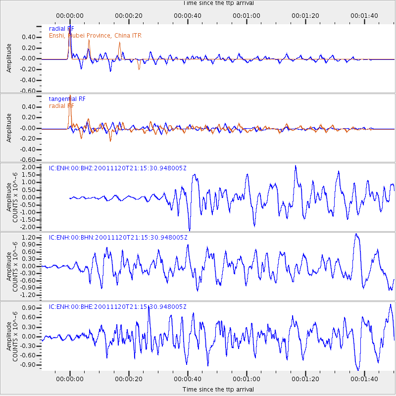
Signal To Noise
| Channel | StoN | STA | LTA |
| IC:ENH:00:BHN:20011120T21:15:30.948005Z | 2.8288171 | 1.2281167E-7 | 4.34145E-8 |
| IC:ENH:00:BHE:20011120T21:15:30.948005Z | 0.8857252 | 6.53689E-8 | 7.3802696E-8 |
| IC:ENH:00:BHZ:20011120T21:15:30.948005Z | 3.7395265 | 3.110696E-7 | 8.3184226E-8 |
| Arrivals |
| Ps | 6.1 SECOND |
| PpPs | 18 SECOND |
| PsPs/PpSs | 24 SECOND |


