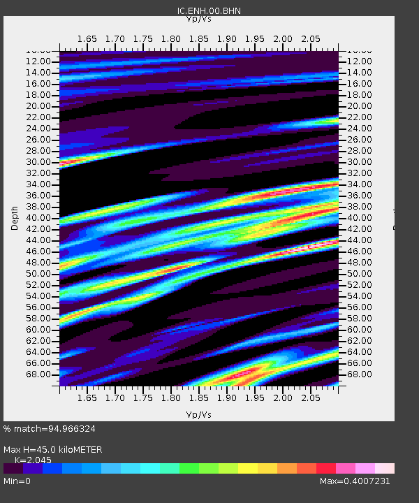
ENH Enshi, Hubei Province, China - Earthquake Result Viewer
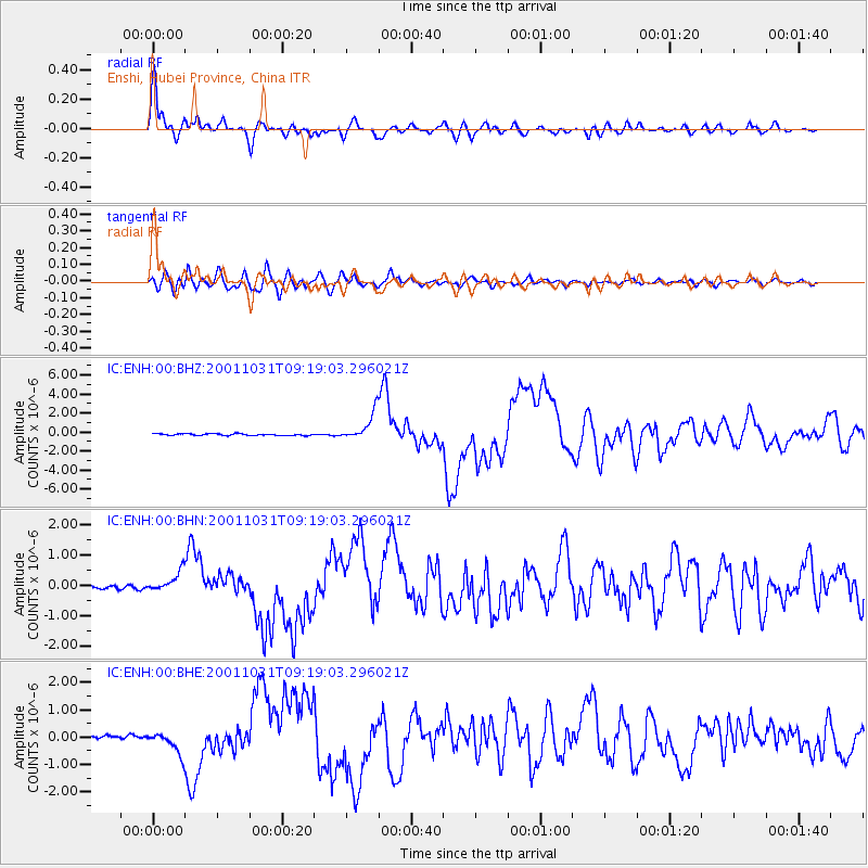
Earthquake location: New Britain Region, P.N.G.
Earthquake latitude/longitude: -5.9/150.2
Earthquake time(UTC): 2001/10/31 (304) 09:10:20 GMT
Earthquake Depth: 33 km
Earthquake Magnitude: 5.9 MB, 6.9 MS, 6.9 MW, 6.9 MW
Earthquake Catalog/Contributor: WHDF/NEIC
Network: IC New China Digital Seismograph Network
Station: ENH Enshi, Hubei Province, China
Lat/Lon: 30.27 N/109.49 E
Elevation: 487 m
Distance: 53.1 deg
Az: 315.091 deg
Baz: 125.731 deg
Ray Param: 0.066292346
Estimated Moho Depth: 45.0 km
Estimated Crust Vp/Vs: 2.05
Assumed Crust Vp: 6.083 km/s
Estimated Crust Vs: 2.975 km/s
Estimated Crust Poisson's Ratio: 0.34
Radial Match: 94.966324 %
Radial Bump: 400
Transverse Match: 86.65898 %
Transverse Bump: 400
SOD ConfigId: 20082
Insert Time: 2010-03-04 21:44:21.135 +0000
GWidth: 2.5
Max Bumps: 400
Tol: 0.001

Signal To Noise

ChannelStoNSTALTA
IC:ENH:00:BHN:20011031T09:19:03.296021Z5.33635573.1909477E-75.9796385E-8
IC:ENH:00:BHE:20011031T09:19:03.296021Z6.24407244.068514E-76.515802E-8
IC:ENH:00:BHZ:20011031T09:19:03.296021Z15.8987911.4505E-69.123335E-8
Arrivals
Ps8.1 SECOND
PpPs22 SECOND
PsPs/PpSs30 SECOND