You are here: Home > Network List > LD - Lamont-Doherty Cooperative Seismographic Network Stations List
> Station KSCT Kent School, Kent, Conneticut > Earthquake Result Viewer
KSCT Kent School, Kent, Conneticut - Earthquake Result Viewer
| Earthquake location: |
Andreanof Islands, Aleutian Is. |
| Earthquake latitude/longitude: |
51.7/-173.1 |
| Earthquake time(UTC): |
2015/11/09 (313) 16:03:45 GMT |
| Earthquake Depth: |
10 km |
| Earthquake Magnitude: |
6.2 MWB, 6.3 MI |
| Earthquake Catalog/Contributor: |
NEIC PDE/NEIC COMCAT |
|
| Network: |
LD Lamont-Doherty Cooperative Seismographic Network |
| Station: |
KSCT Kent School, Kent, Conneticut |
| Lat/Lon: |
41.73 N/73.48 W |
| Elevation: |
114 m |
|
| Distance: |
63.8 deg |
| Az: |
55.362 deg |
| Baz: |
316.882 deg |
| Ray Param: |
0.059353136 |
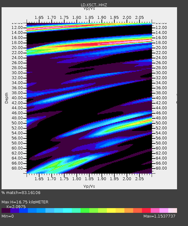
| Estimated Moho Depth: |
16.75 km |
| Estimated Crust Vp/Vs: |
2.10 |
| Assumed Crust Vp: |
6.472 km/s |
| Estimated Crust Vs: |
3.086 km/s |
| Estimated Crust Poisson's Ratio: |
0.35 |
|
| Radial Match: |
83.16106 % |
| Radial Bump: |
364 |
| Transverse Match: |
66.08073 % |
| Transverse Bump: |
400 |
| SOD ConfigId: |
7422571 |
| Insert Time: |
2019-04-21 07:48:21.694 +0000 |
| GWidth: |
2.5 |
| Max Bumps: |
400 |
| Tol: |
0.001 |
|

Signal To Noise
| Channel | StoN | STA | LTA |
| LD:KSCT: :HHZ:20151109T16:13:46.590005Z | 3.6081486 | 1.4401714E-6 | 3.991442E-7 |
| LD:KSCT: :HHN:20151109T16:13:46.590005Z | 1.06482 | 3.084106E-7 | 2.8963635E-7 |
| LD:KSCT: :HHE:20151109T16:13:46.590005Z | 2.975056 | 5.6633894E-7 | 1.9036246E-7 |
| Arrivals |
| Ps | 2.9 SECOND |
| PpPs | 7.7 SECOND |
| PsPs/PpSs | 11 SECOND |


