You are here: Home > Network List > LD - Lamont-Doherty Cooperative Seismographic Network Stations List
> Station LUPA Lehigh University, PA > Earthquake Result Viewer
LUPA Lehigh University, PA - Earthquake Result Viewer

| Earthquake location: |
Andreanof Islands, Aleutian Is. |
| Earthquake latitude/longitude: |
51.7/-173.1 |
| Earthquake time(UTC): |
2015/11/09 (313) 16:03:45 GMT |
| Earthquake Depth: |
10 km |
| Earthquake Magnitude: |
6.2 MWB, 6.3 MI |
| Earthquake Catalog/Contributor: |
NEIC PDE/NEIC COMCAT |
|
| Network: |
LD Lamont-Doherty Cooperative Seismographic Network |
| Station: |
LUPA Lehigh University, PA |
| Lat/Lon: |
40.60 N/75.37 W |
| Elevation: |
236 m |
|
| Distance: |
63.6 deg |
| Az: |
57.38 deg |
| Baz: |
316.539 deg |
| Ray Param: |
0.059456166 |
| Estimated Moho Depth: |
54.75 km |
| Estimated Crust Vp/Vs: |
2.10 |
| Assumed Crust Vp: |
6.283 km/s |
| Estimated Crust Vs: |
2.996 km/s |
| Estimated Crust Poisson's Ratio: |
0.35 |
|
| Radial Match: |
80.643936 % |
| Radial Bump: |
400 |
| Transverse Match: |
67.46385 % |
| Transverse Bump: |
400 |
| SOD ConfigId: |
7422571 |
| Insert Time: |
2019-04-21 07:48:25.020 +0000 |
| GWidth: |
2.5 |
| Max Bumps: |
400 |
| Tol: |
0.001 |
|
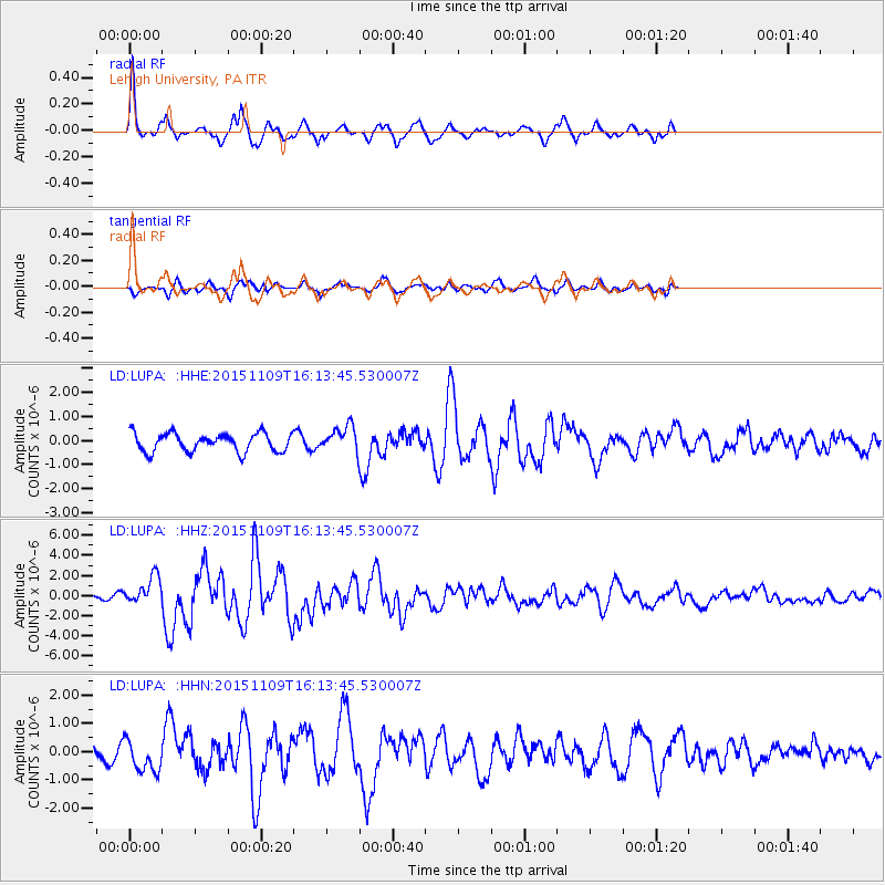
Signal To Noise
| Channel | StoN | STA | LTA |
| LD:LUPA: :HHZ:20151109T16:13:45.530007Z | 8.045507 | 1.4076708E-6 | 1.7496357E-7 |
| LD:LUPA: :HHN:20151109T16:13:45.530007Z | 1.7568036 | 5.713837E-7 | 3.2524048E-7 |
| LD:LUPA: :HHE:20151109T16:13:45.530007Z | 1.3432885 | 5.076197E-7 | 3.7789326E-7 |
| Arrivals |
| Ps | 9.9 SECOND |
| PpPs | 26 SECOND |
| PsPs/PpSs | 36 SECOND |


