You are here: Home > Network List > IC - New China Digital Seismograph Network Stations List
> Station ENH Enshi, Hubei Province, China > Earthquake Result Viewer
ENH Enshi, Hubei Province, China - Earthquake Result Viewer

| Earthquake location: |
Bismarck Sea |
| Earthquake latitude/longitude: |
-3.4/146.3 |
| Earthquake time(UTC): |
2001/08/23 (235) 21:45:03 GMT |
| Earthquake Depth: |
10 km |
| Earthquake Magnitude: |
5.8 MB, 6.2 MS, 6.2 MW, 6.0 MW |
| Earthquake Catalog/Contributor: |
WHDF/NEIC |
|
| Network: |
IC New China Digital Seismograph Network |
| Station: |
ENH Enshi, Hubei Province, China |
| Lat/Lon: |
30.27 N/109.49 E |
| Elevation: |
487 m |
|
| Distance: |
48.5 deg |
| Az: |
316.226 deg |
| Baz: |
127.03 deg |
| Ray Param: |
0.0692894 |
| Estimated Moho Depth: |
11.25 km |
| Estimated Crust Vp/Vs: |
1.60 |
| Assumed Crust Vp: |
6.083 km/s |
| Estimated Crust Vs: |
3.802 km/s |
| Estimated Crust Poisson's Ratio: |
0.18 |
|
| Radial Match: |
93.56038 % |
| Radial Bump: |
400 |
| Transverse Match: |
80.448616 % |
| Transverse Bump: |
400 |
| SOD ConfigId: |
20082 |
| Insert Time: |
2010-03-04 21:44:38.417 +0000 |
| GWidth: |
2.5 |
| Max Bumps: |
400 |
| Tol: |
0.001 |
|
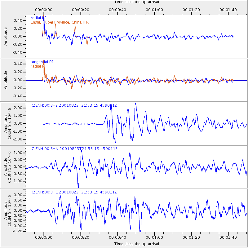
Signal To Noise
| Channel | StoN | STA | LTA |
| IC:ENH:00:BHN:20010823T21:53:15.459011Z | 3.1933277 | 1.2230907E-7 | 3.830145E-8 |
| IC:ENH:00:BHE:20010823T21:53:15.459011Z | 3.027083 | 1.1697456E-7 | 3.8642668E-8 |
| IC:ENH:00:BHZ:20010823T21:53:15.459011Z | 7.6822195 | 4.1668486E-7 | 5.424016E-8 |
| Arrivals |
| Ps | 1.2 SECOND |
| PpPs | 4.5 SECOND |
| PsPs/PpSs | 5.7 SECOND |


