You are here: Home > Network List > IC - New China Digital Seismograph Network Stations List
> Station ENH Enshi, Hubei Province, China > Earthquake Result Viewer
ENH Enshi, Hubei Province, China - Earthquake Result Viewer

| Earthquake location: |
Vanuatu Islands |
| Earthquake latitude/longitude: |
-14.9/167.2 |
| Earthquake time(UTC): |
2001/01/09 (009) 16:49:28 GMT |
| Earthquake Depth: |
103 km |
| Earthquake Magnitude: |
6.3 MB, 6.6 MS, 7.6 ME, 7.0 MW |
| Earthquake Catalog/Contributor: |
WHDF/NEIC |
|
| Network: |
IC New China Digital Seismograph Network |
| Station: |
ENH Enshi, Hubei Province, China |
| Lat/Lon: |
30.27 N/109.49 E |
| Elevation: |
487 m |
|
| Distance: |
71.4 deg |
| Az: |
309.527 deg |
| Baz: |
120.472 deg |
| Ray Param: |
0.054085754 |
| Estimated Moho Depth: |
35.5 km |
| Estimated Crust Vp/Vs: |
2.08 |
| Assumed Crust Vp: |
6.083 km/s |
| Estimated Crust Vs: |
2.931 km/s |
| Estimated Crust Poisson's Ratio: |
0.35 |
|
| Radial Match: |
93.39653 % |
| Radial Bump: |
400 |
| Transverse Match: |
88.29386 % |
| Transverse Bump: |
400 |
| SOD ConfigId: |
3744 |
| Insert Time: |
2010-03-04 21:44:54.470 +0000 |
| GWidth: |
2.5 |
| Max Bumps: |
400 |
| Tol: |
0.001 |
|
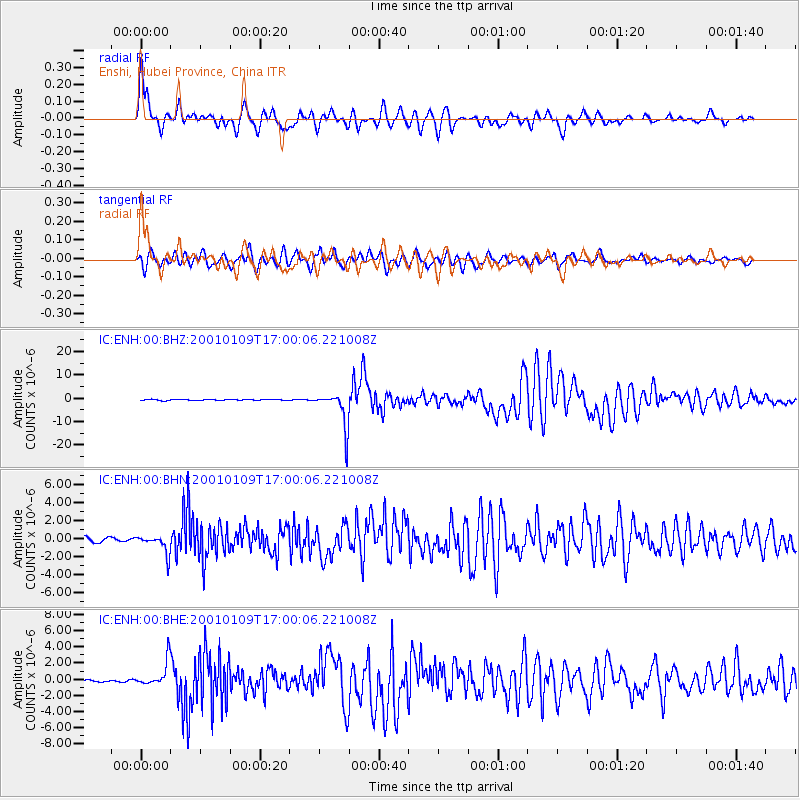
Signal To Noise
| Channel | StoN | STA | LTA |
| IC:ENH:00:BHN:20010109T17:00:06.221008Z | 4.0661798 | 1.043764E-6 | 2.56694E-7 |
| IC:ENH:00:BHE:20010109T17:00:06.221008Z | 10.108412 | 1.5536273E-6 | 1.5369648E-7 |
| IC:ENH:00:BHZ:20010109T17:00:06.221008Z | 43.64204 | 7.791156E-6 | 1.7852412E-7 |
| Arrivals |
| Ps | 6.4 SECOND |
| PpPs | 17 SECOND |
| PsPs/PpSs | 24 SECOND |


