You are here: Home > Network List > N4 - Central and EAstern US Network Stations List
> Station Q51A Peebles, OH, USA > Earthquake Result Viewer
Q51A Peebles, OH, USA - Earthquake Result Viewer
| Earthquake location: |
Andreanof Islands, Aleutian Is. |
| Earthquake latitude/longitude: |
51.7/-173.1 |
| Earthquake time(UTC): |
2015/11/09 (313) 16:03:45 GMT |
| Earthquake Depth: |
10 km |
| Earthquake Magnitude: |
6.2 MWB, 6.3 MI |
| Earthquake Catalog/Contributor: |
NEIC PDE/NEIC COMCAT |
|
| Network: |
N4 Central and EAstern US Network |
| Station: |
Q51A Peebles, OH, USA |
| Lat/Lon: |
39.03 N/83.35 W |
| Elevation: |
362 m |
|
| Distance: |
60.4 deg |
| Az: |
63.58 deg |
| Baz: |
314.359 deg |
| Ray Param: |
0.061537433 |
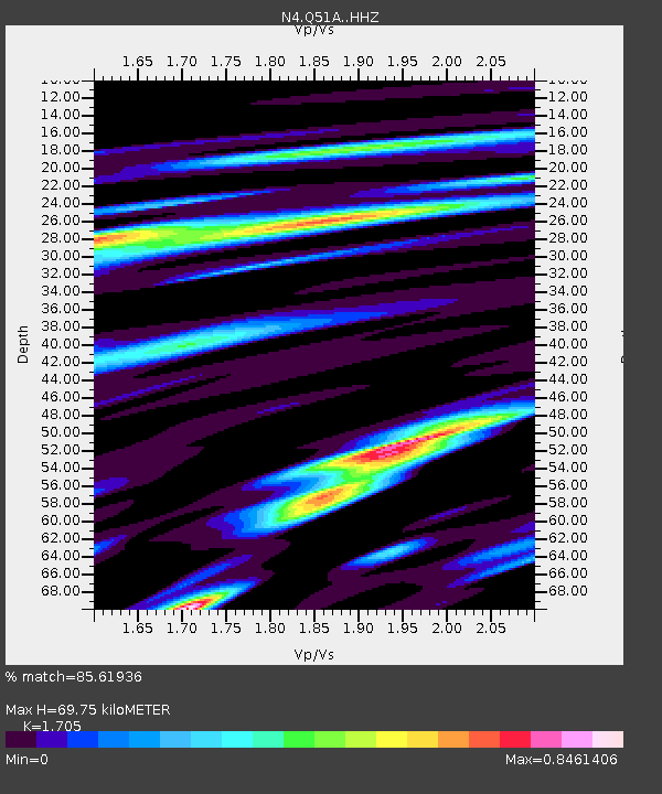
| Estimated Moho Depth: |
69.75 km |
| Estimated Crust Vp/Vs: |
1.71 |
| Assumed Crust Vp: |
6.232 km/s |
| Estimated Crust Vs: |
3.655 km/s |
| Estimated Crust Poisson's Ratio: |
0.24 |
|
| Radial Match: |
85.61936 % |
| Radial Bump: |
335 |
| Transverse Match: |
51.855328 % |
| Transverse Bump: |
400 |
| SOD ConfigId: |
7422571 |
| Insert Time: |
2019-04-21 07:49:57.981 +0000 |
| GWidth: |
2.5 |
| Max Bumps: |
400 |
| Tol: |
0.001 |
|

Signal To Noise
| Channel | StoN | STA | LTA |
| N4:Q51A: :HHZ:20151109T16:13:24.079995Z | 5.4540114 | 1.3118228E-6 | 2.405244E-7 |
| N4:Q51A: :HHN:20151109T16:13:24.079995Z | 2.01222 | 6.135842E-7 | 3.0492902E-7 |
| N4:Q51A: :HHE:20151109T16:13:24.079995Z | 2.1764362 | 6.151762E-7 | 2.82653E-7 |
| Arrivals |
| Ps | 8.3 SECOND |
| PpPs | 29 SECOND |
| PsPs/PpSs | 37 SECOND |


