You are here: Home > Network List > N4 - Central and EAstern US Network Stations List
> Station R50A Paris, KY, USA > Earthquake Result Viewer
R50A Paris, KY, USA - Earthquake Result Viewer
| Earthquake location: |
Andreanof Islands, Aleutian Is. |
| Earthquake latitude/longitude: |
51.7/-173.1 |
| Earthquake time(UTC): |
2015/11/09 (313) 16:03:45 GMT |
| Earthquake Depth: |
10 km |
| Earthquake Magnitude: |
6.2 MWB, 6.3 MI |
| Earthquake Catalog/Contributor: |
NEIC PDE/NEIC COMCAT |
|
| Network: |
N4 Central and EAstern US Network |
| Station: |
R50A Paris, KY, USA |
| Lat/Lon: |
38.28 N/84.33 W |
| Elevation: |
255 m |
|
| Distance: |
60.4 deg |
| Az: |
64.809 deg |
| Baz: |
314.355 deg |
| Ray Param: |
0.06155727 |
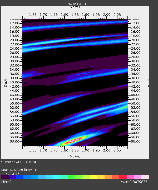
| Estimated Moho Depth: |
67.25 km |
| Estimated Crust Vp/Vs: |
1.85 |
| Assumed Crust Vp: |
6.498 km/s |
| Estimated Crust Vs: |
3.522 km/s |
| Estimated Crust Poisson's Ratio: |
0.29 |
|
| Radial Match: |
88.849174 % |
| Radial Bump: |
218 |
| Transverse Match: |
72.98708 % |
| Transverse Bump: |
384 |
| SOD ConfigId: |
7422571 |
| Insert Time: |
2019-04-21 07:50:01.506 +0000 |
| GWidth: |
2.5 |
| Max Bumps: |
400 |
| Tol: |
0.001 |
|

Signal To Noise
| Channel | StoN | STA | LTA |
| N4:R50A: :HHZ:20151109T16:13:23.860024Z | 3.11599 | 1.0616814E-6 | 3.4072042E-7 |
| N4:R50A: :HHN:20151109T16:13:23.860024Z | 2.3938599 | 3.612129E-7 | 1.5089141E-7 |
| N4:R50A: :HHE:20151109T16:13:23.860024Z | 1.5151911 | 3.2813568E-7 | 2.165639E-7 |
| Arrivals |
| Ps | 9.2 SECOND |
| PpPs | 28 SECOND |
| PsPs/PpSs | 37 SECOND |


