You are here: Home > Network List > IC - New China Digital Seismograph Network Stations List
> Station ENH Enshi, Hubei Province, China > Earthquake Result Viewer
ENH Enshi, Hubei Province, China - Earthquake Result Viewer
| Earthquake location: |
Southern Alaska |
| Earthquake latitude/longitude: |
59.0/-155.1 |
| Earthquake time(UTC): |
2001/07/28 (209) 07:32:43 GMT |
| Earthquake Depth: |
131 km |
| Earthquake Magnitude: |
5.7 MB, 5.7 MS, 6.6 MW, 6.2 ME |
| Earthquake Catalog/Contributor: |
WHDF/NEIC |
|
| Network: |
IC New China Digital Seismograph Network |
| Station: |
ENH Enshi, Hubei Province, China |
| Lat/Lon: |
30.27 N/109.49 E |
| Elevation: |
487 m |
|
| Distance: |
67.2 deg |
| Az: |
290.91 deg |
| Baz: |
33.95 deg |
| Ray Param: |
0.056744285 |
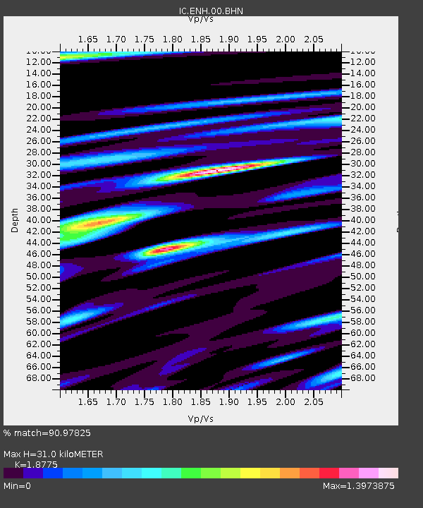
| Estimated Moho Depth: |
31.0 km |
| Estimated Crust Vp/Vs: |
1.88 |
| Assumed Crust Vp: |
6.083 km/s |
| Estimated Crust Vs: |
3.24 km/s |
| Estimated Crust Poisson's Ratio: |
0.30 |
|
| Radial Match: |
90.97825 % |
| Radial Bump: |
400 |
| Transverse Match: |
86.99705 % |
| Transverse Bump: |
400 |
| SOD ConfigId: |
4714 |
| Insert Time: |
2010-03-04 21:45:42.987 +0000 |
| GWidth: |
2.5 |
| Max Bumps: |
400 |
| Tol: |
0.001 |
|
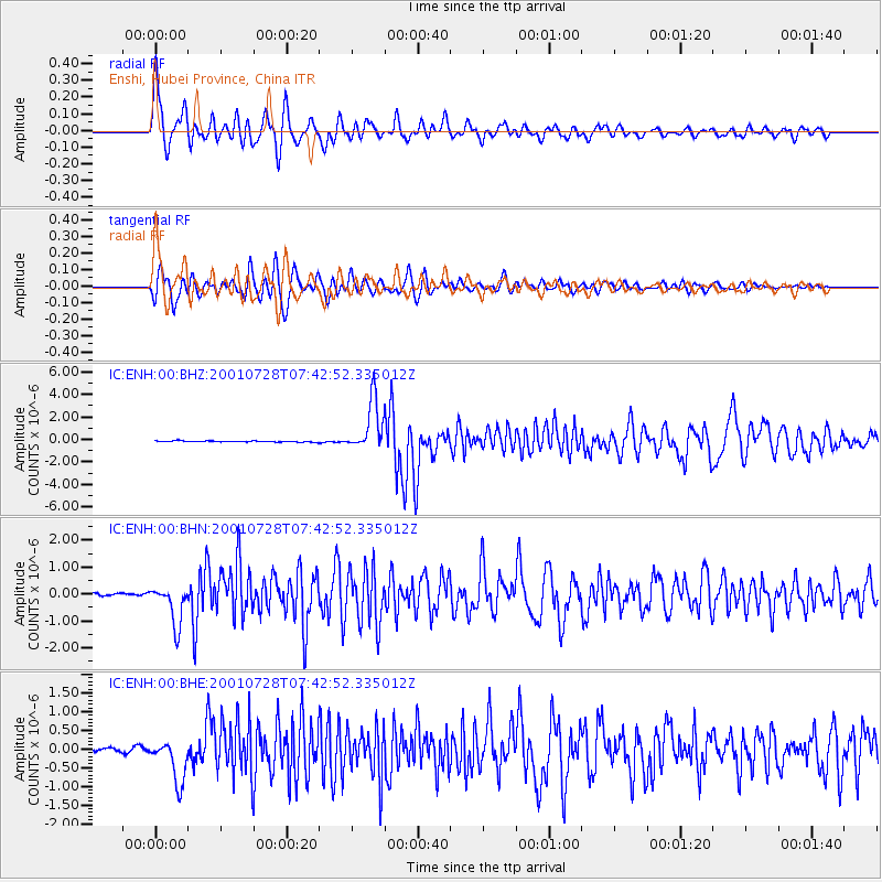
Signal To Noise
| Channel | StoN | STA | LTA |
| IC:ENH:00:BHN:20010728T07:42:52.335012Z | 18.386711 | 7.382093E-7 | 4.0149068E-8 |
| IC:ENH:00:BHE:20010728T07:42:52.335012Z | 12.96447 | 5.7467156E-7 | 4.4326654E-8 |
| IC:ENH:00:BHZ:20010728T07:42:52.335012Z | 45.14109 | 2.253414E-6 | 4.9919354E-8 |
| Arrivals |
| Ps | 4.6 SECOND |
| PpPs | 14 SECOND |
| PsPs/PpSs | 19 SECOND |


