You are here: Home > Network List > TA - USArray Transportable Network (new EarthScope stations) Stations List
> Station O03E Paynes Creek, CA, USA > Earthquake Result Viewer
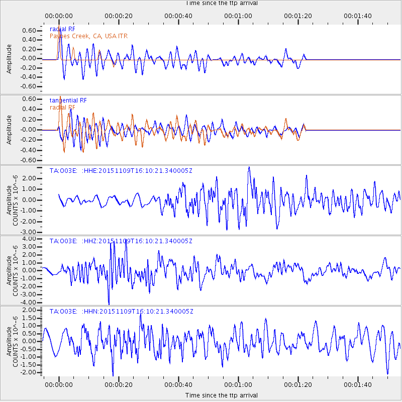
O03E Paynes Creek, CA, USA - Earthquake Result Viewer
*The percent match for this event was below the threshold and hence no stack was calculated.
| Earthquake location: |
Andreanof Islands, Aleutian Is. |
| Earthquake latitude/longitude: |
51.7/-173.1 |
| Earthquake time(UTC): |
2015/11/09 (313) 16:03:45 GMT |
| Earthquake Depth: |
10 km |
| Earthquake Magnitude: |
6.2 MWB, 6.3 MI |
| Earthquake Catalog/Contributor: |
NEIC PDE/NEIC COMCAT |
|
| Network: |
TA USArray Transportable Network (new EarthScope stations) |
| Station: |
O03E Paynes Creek, CA, USA |
| Lat/Lon: |
40.29 N/121.80 W |
| Elevation: |
967 m |
|
| Distance: |
36.7 deg |
| Az: |
87.525 deg |
| Baz: |
305.682 deg |
| Ray Param: |
$rayparam |
*The percent match for this event was below the threshold and hence was not used in the summary stack. |
|
| Radial Match: |
75.03074 % |
| Radial Bump: |
400 |
| Transverse Match: |
64.832504 % |
| Transverse Bump: |
400 |
| SOD ConfigId: |
7422571 |
| Insert Time: |
2019-04-21 07:53:35.412 +0000 |
| GWidth: |
2.5 |
| Max Bumps: |
400 |
| Tol: |
0.001 |
|
Signal To Noise
| Channel | StoN | STA | LTA |
| TA:O03E: :HHZ:20151109T16:10:21.340005Z | 1.7538675 | 5.50773E-7 | 3.1403343E-7 |
| TA:O03E: :HHN:20151109T16:10:21.340005Z | 1.239974 | 5.619597E-7 | 4.5320283E-7 |
| TA:O03E: :HHE:20151109T16:10:21.340005Z | 1.4737988 | 4.3918092E-7 | 2.9799244E-7 |
| Arrivals |
| Ps | |
| PpPs | |
| PsPs/PpSs | |


