You are here: Home > Network List > TA - USArray Transportable Network (new EarthScope stations) Stations List
> Station WHTX Lake Whitney, Meridian, TX, USA > Earthquake Result Viewer
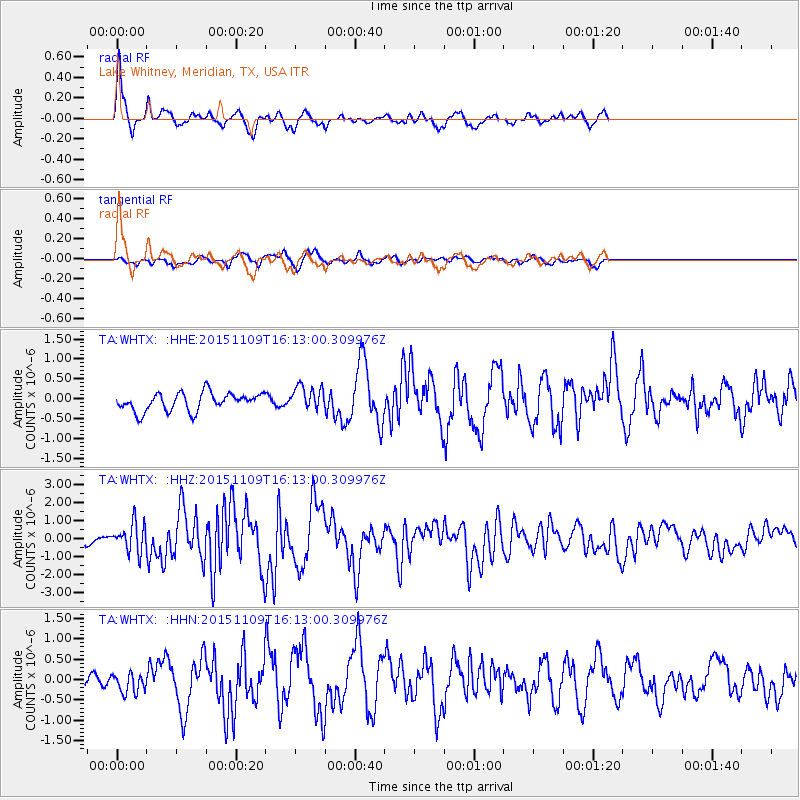
WHTX Lake Whitney, Meridian, TX, USA - Earthquake Result Viewer
| Earthquake location: |
Andreanof Islands, Aleutian Is. |
| Earthquake latitude/longitude: |
51.7/-173.1 |
| Earthquake time(UTC): |
2015/11/09 (313) 16:03:45 GMT |
| Earthquake Depth: |
10 km |
| Earthquake Magnitude: |
6.2 MWB, 6.3 MI |
| Earthquake Catalog/Contributor: |
NEIC PDE/NEIC COMCAT |
|
| Network: |
TA USArray Transportable Network (new EarthScope stations) |
| Station: |
WHTX Lake Whitney, Meridian, TX, USA |
| Lat/Lon: |
31.99 N/97.46 W |
| Elevation: |
190 m |
|
| Distance: |
57.0 deg |
| Az: |
78.832 deg |
| Baz: |
314.112 deg |
| Ray Param: |
0.063754216 |
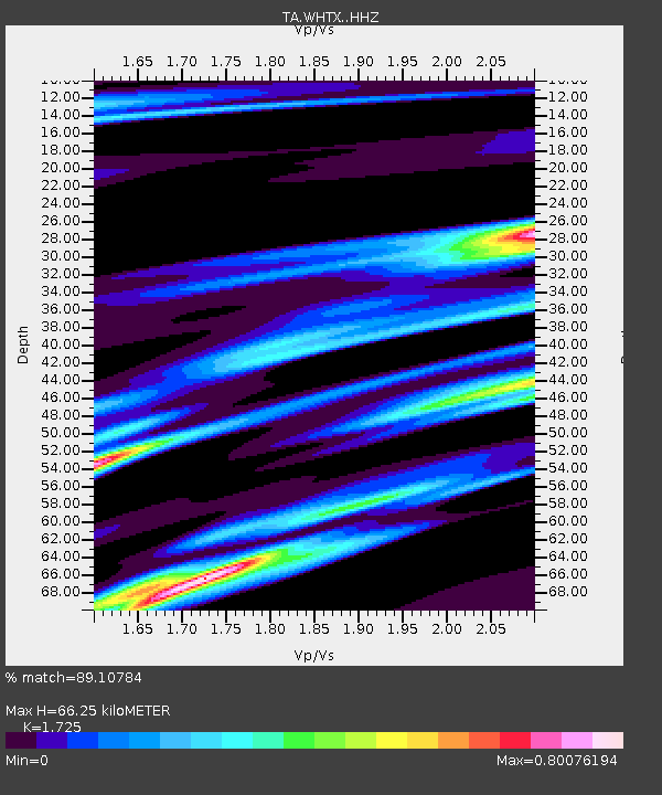
| Estimated Moho Depth: |
66.25 km |
| Estimated Crust Vp/Vs: |
1.73 |
| Assumed Crust Vp: |
6.347 km/s |
| Estimated Crust Vs: |
3.679 km/s |
| Estimated Crust Poisson's Ratio: |
0.25 |
|
| Radial Match: |
89.10784 % |
| Radial Bump: |
367 |
| Transverse Match: |
60.100437 % |
| Transverse Bump: |
400 |
| SOD ConfigId: |
7422571 |
| Insert Time: |
2019-04-21 07:53:50.000 +0000 |
| GWidth: |
2.5 |
| Max Bumps: |
400 |
| Tol: |
0.001 |
|
Signal To Noise
| Channel | StoN | STA | LTA |
| TA:WHTX: :HHZ:20151109T16:13:00.309976Z | 6.2414947 | 8.040803E-7 | 1.2882816E-7 |
| TA:WHTX: :HHN:20151109T16:13:00.309976Z | 1.4108435 | 2.3138692E-7 | 1.6400608E-7 |
| TA:WHTX: :HHE:20151109T16:13:00.309976Z | 1.3375472 | 3.0274444E-7 | 2.2634299E-7 |
| Arrivals |
| Ps | 8.0 SECOND |
| PpPs | 27 SECOND |
| PsPs/PpSs | 35 SECOND |


