You are here: Home > Network List > IC - New China Digital Seismograph Network Stations List
> Station ENH Enshi, Hubei Province, China > Earthquake Result Viewer
ENH Enshi, Hubei Province, China - Earthquake Result Viewer
| Earthquake location: |
Fiji Islands Region |
| Earthquake latitude/longitude: |
-16.4/173.3 |
| Earthquake time(UTC): |
2002/04/20 (110) 15:59:57 GMT |
| Earthquake Depth: |
33 km |
| Earthquake Magnitude: |
6.0 MB, 5.5 MS, 6.0 MW, 5.9 MW |
| Earthquake Catalog/Contributor: |
WHDF/NEIC |
|
| Network: |
IC New China Digital Seismograph Network |
| Station: |
ENH Enshi, Hubei Province, China |
| Lat/Lon: |
30.27 N/109.49 E |
| Elevation: |
487 m |
|
| Distance: |
76.9 deg |
| Az: |
307.181 deg |
| Baz: |
117.866 deg |
| Ray Param: |
0.05062809 |
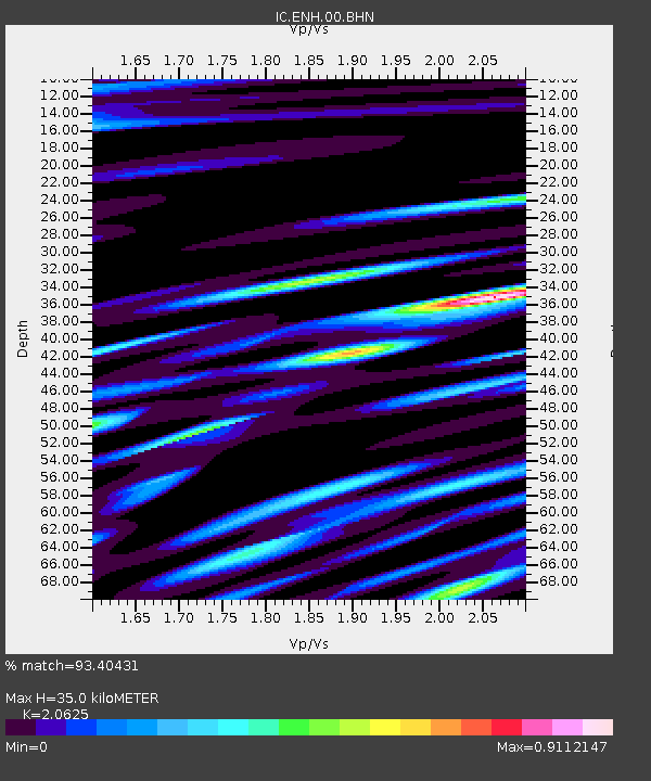
| Estimated Moho Depth: |
35.0 km |
| Estimated Crust Vp/Vs: |
2.06 |
| Assumed Crust Vp: |
6.083 km/s |
| Estimated Crust Vs: |
2.949 km/s |
| Estimated Crust Poisson's Ratio: |
0.35 |
|
| Radial Match: |
93.40431 % |
| Radial Bump: |
400 |
| Transverse Match: |
94.389565 % |
| Transverse Bump: |
400 |
| SOD ConfigId: |
20082 |
| Insert Time: |
2010-03-04 21:46:26.665 +0000 |
| GWidth: |
2.5 |
| Max Bumps: |
400 |
| Tol: |
0.001 |
|

Signal To Noise
| Channel | StoN | STA | LTA |
| IC:ENH:00:BHN:20020420T16:11:15.786025Z | 4.3067255 | 1.755518E-7 | 4.076225E-8 |
| IC:ENH:00:BHE:20020420T16:11:15.786025Z | 10.032416 | 3.2075684E-7 | 3.1972043E-8 |
| IC:ENH:00:BHZ:20020420T16:11:15.786025Z | 24.387585 | 1.4996327E-6 | 6.149165E-8 |
| Arrivals |
| Ps | 6.3 SECOND |
| PpPs | 17 SECOND |
| PsPs/PpSs | 23 SECOND |


