You are here: Home > Network List > YN10 - San Jacinto Fault Zone Stations List
> Station JFS3 JFS3 > Earthquake Result Viewer
JFS3 JFS3 - Earthquake Result Viewer
| Earthquake location: |
Andreanof Islands, Aleutian Is. |
| Earthquake latitude/longitude: |
51.7/-173.1 |
| Earthquake time(UTC): |
2015/11/09 (313) 16:03:45 GMT |
| Earthquake Depth: |
10 km |
| Earthquake Magnitude: |
6.2 MWB, 6.3 MI |
| Earthquake Catalog/Contributor: |
NEIC PDE/NEIC COMCAT |
|
| Network: |
YN San Jacinto Fault Zone |
| Station: |
JFS3 JFS3 |
| Lat/Lon: |
33.42 N/116.40 W |
| Elevation: |
645 m |
|
| Distance: |
44.3 deg |
| Az: |
91.558 deg |
| Baz: |
311.988 deg |
| Ray Param: |
0.071974255 |
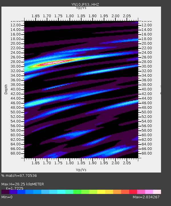
| Estimated Moho Depth: |
28.25 km |
| Estimated Crust Vp/Vs: |
1.72 |
| Assumed Crust Vp: |
6.264 km/s |
| Estimated Crust Vs: |
3.636 km/s |
| Estimated Crust Poisson's Ratio: |
0.25 |
|
| Radial Match: |
87.70536 % |
| Radial Bump: |
400 |
| Transverse Match: |
72.24821 % |
| Transverse Bump: |
400 |
| SOD ConfigId: |
7422571 |
| Insert Time: |
2019-04-21 07:56:36.132 +0000 |
| GWidth: |
2.5 |
| Max Bumps: |
400 |
| Tol: |
0.001 |
|

Signal To Noise
| Channel | StoN | STA | LTA |
| YN:JFS3: :HHZ:20151109T16:11:24.638986Z | 5.6676035 | 6.2977944E-7 | 1.1111918E-7 |
| YN:JFS3: :HHN:20151109T16:11:24.638986Z | 1.0795368 | 1.9142038E-7 | 1.7731716E-7 |
| YN:JFS3: :HHE:20151109T16:11:24.638986Z | 2.4074674 | 4.4959742E-7 | 1.8675121E-7 |
| Arrivals |
| Ps | 3.5 SECOND |
| PpPs | 12 SECOND |
| PsPs/PpSs | 15 SECOND |


