You are here: Home > Network List > AZ - ANZA Regional Network Stations List
> Station SMER AZ.SMER > Earthquake Result Viewer
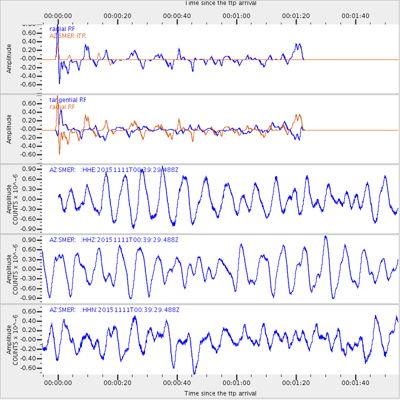
SMER AZ.SMER - Earthquake Result Viewer
*The percent match for this event was below the threshold and hence no stack was calculated.
| Earthquake location: |
E. Caroline Islands, Micronesia |
| Earthquake latitude/longitude: |
6.2/147.6 |
| Earthquake time(UTC): |
2015/11/11 (315) 00:26:58 GMT |
| Earthquake Depth: |
15 km |
| Earthquake Magnitude: |
5.6 MB |
| Earthquake Catalog/Contributor: |
NEIC PDE/NEIC ALERT |
|
| Network: |
AZ ANZA Regional Network |
| Station: |
SMER AZ.SMER |
| Lat/Lon: |
33.46 N/117.17 W |
| Elevation: |
355 m |
|
| Distance: |
90.9 deg |
| Az: |
56.373 deg |
| Baz: |
278.01 deg |
| Ray Param: |
$rayparam |
*The percent match for this event was below the threshold and hence was not used in the summary stack. |
|
| Radial Match: |
73.27541 % |
| Radial Bump: |
400 |
| Transverse Match: |
58.070675 % |
| Transverse Bump: |
400 |
| SOD ConfigId: |
7422571 |
| Insert Time: |
2019-04-21 07:58:35.054 +0000 |
| GWidth: |
2.5 |
| Max Bumps: |
400 |
| Tol: |
0.001 |
|
Signal To Noise
| Channel | StoN | STA | LTA |
| AZ:SMER: :HHZ:20151111T00:39:29.488Z | 1.6016207 | 4.5978533E-7 | 2.8707504E-7 |
| AZ:SMER: :HHN:20151111T00:39:29.488Z | 1.268255 | 2.6513297E-7 | 2.0905335E-7 |
| AZ:SMER: :HHE:20151111T00:39:29.488Z | 1.2388947 | 4.624425E-7 | 3.7327024E-7 |
| Arrivals |
| Ps | |
| PpPs | |
| PsPs/PpSs | |


