You are here: Home > Network List > IC - New China Digital Seismograph Network Stations List
> Station ENH Enshi, Hubei Province, China > Earthquake Result Viewer
ENH Enshi, Hubei Province, China - Earthquake Result Viewer
| Earthquake location: |
Vanuatu Islands |
| Earthquake latitude/longitude: |
-17.6/167.9 |
| Earthquake time(UTC): |
2002/01/02 (002) 17:22:48 GMT |
| Earthquake Depth: |
21 km |
| Earthquake Magnitude: |
6.3 MB, 7.5 MS, 7.3 MW, 7.1 MW |
| Earthquake Catalog/Contributor: |
WHDF/NEIC |
|
| Network: |
IC New China Digital Seismograph Network |
| Station: |
ENH Enshi, Hubei Province, China |
| Lat/Lon: |
30.27 N/109.49 E |
| Elevation: |
487 m |
|
| Distance: |
73.6 deg |
| Az: |
309.847 deg |
| Baz: |
122.174 deg |
| Ray Param: |
0.0528606 |
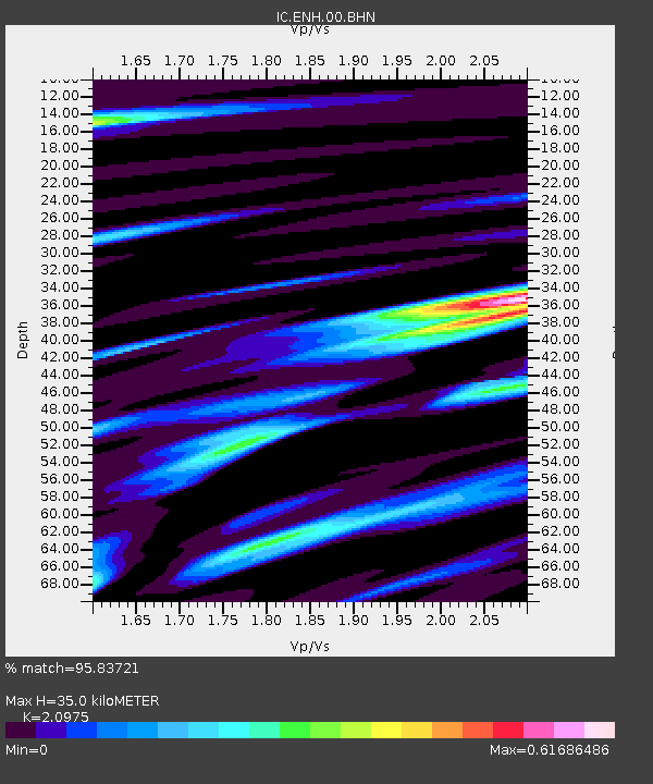
| Estimated Moho Depth: |
35.0 km |
| Estimated Crust Vp/Vs: |
2.10 |
| Assumed Crust Vp: |
6.083 km/s |
| Estimated Crust Vs: |
2.9 km/s |
| Estimated Crust Poisson's Ratio: |
0.35 |
|
| Radial Match: |
95.83721 % |
| Radial Bump: |
400 |
| Transverse Match: |
88.638054 % |
| Transverse Bump: |
400 |
| SOD ConfigId: |
20082 |
| Insert Time: |
2010-03-04 21:46:49.136 +0000 |
| GWidth: |
2.5 |
| Max Bumps: |
400 |
| Tol: |
0.001 |
|

Signal To Noise
| Channel | StoN | STA | LTA |
| IC:ENH:00:BHN:20020102T17:33:49.247Z | 2.6653545 | 2.8796785E-7 | 1.08041114E-7 |
| IC:ENH:00:BHE:20020102T17:33:49.247Z | 4.8158255 | 3.6092788E-7 | 7.4946215E-8 |
| IC:ENH:00:BHZ:20020102T17:33:49.247Z | 15.281557 | 1.6281546E-6 | 1.06543766E-7 |
| Arrivals |
| Ps | 6.5 SECOND |
| PpPs | 17 SECOND |
| PsPs/PpSs | 24 SECOND |


