You are here: Home > Network List > PF - Volcanologic Network of Piton de Fournaise-OVPF Stations List
> Station CIL Cilaos (Pompiers) > Earthquake Result Viewer
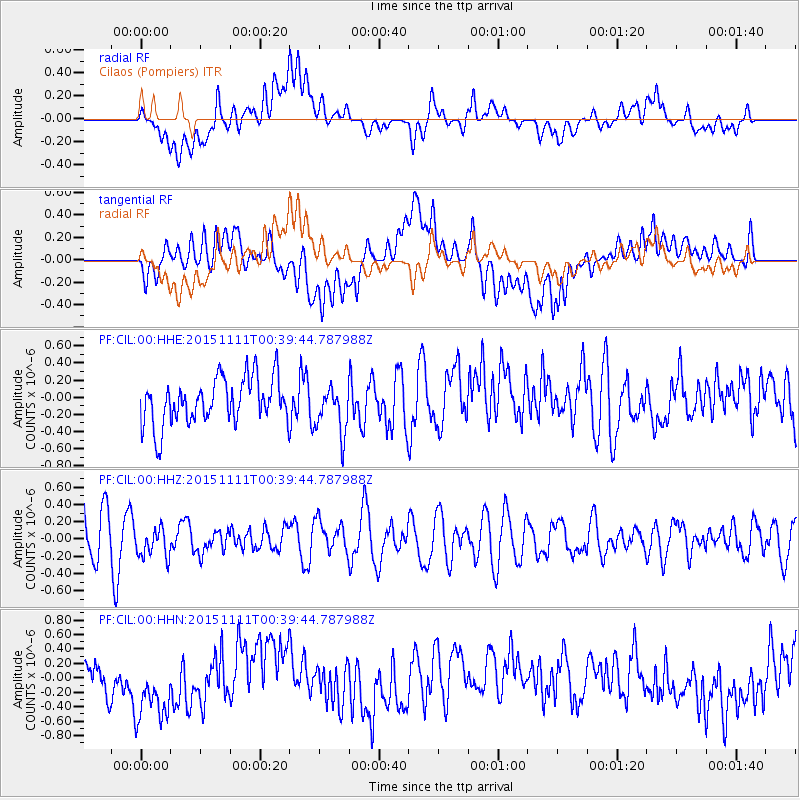
CIL Cilaos (Pompiers) - Earthquake Result Viewer
*The percent match for this event was below the threshold and hence no stack was calculated.
| Earthquake location: |
E. Caroline Islands, Micronesia |
| Earthquake latitude/longitude: |
6.2/147.6 |
| Earthquake time(UTC): |
2015/11/11 (315) 00:26:58 GMT |
| Earthquake Depth: |
15 km |
| Earthquake Magnitude: |
5.6 MB |
| Earthquake Catalog/Contributor: |
NEIC PDE/NEIC ALERT |
|
| Network: |
PF Volcanologic Network of Piton de Fournaise-OVPF |
| Station: |
CIL Cilaos (Pompiers) |
| Lat/Lon: |
21.13 S/55.47 E |
| Elevation: |
1223 m |
|
| Distance: |
94.2 deg |
| Az: |
249.296 deg |
| Baz: |
84.999 deg |
| Ray Param: |
$rayparam |
*The percent match for this event was below the threshold and hence was not used in the summary stack. |
|
| Radial Match: |
37.716103 % |
| Radial Bump: |
400 |
| Transverse Match: |
39.860794 % |
| Transverse Bump: |
400 |
| SOD ConfigId: |
7422571 |
| Insert Time: |
2019-04-21 08:00:36.784 +0000 |
| GWidth: |
2.5 |
| Max Bumps: |
400 |
| Tol: |
0.001 |
|
Signal To Noise
| Channel | StoN | STA | LTA |
| PF:CIL:00:HHZ:20151111T00:39:44.787988Z | 0.9087945 | 1.8012804E-7 | 1.9820547E-7 |
| PF:CIL:00:HHN:20151111T00:39:44.787988Z | 1.5305995 | 5.440885E-7 | 3.554741E-7 |
| PF:CIL:00:HHE:20151111T00:39:44.787988Z | 1.0618658 | 2.8291703E-7 | 2.664339E-7 |
| Arrivals |
| Ps | |
| PpPs | |
| PsPs/PpSs | |


