You are here: Home > Network List > TA - USArray Transportable Network (new EarthScope stations) Stations List
> Station POKR Poker Plat Research Range, AK, USA > Earthquake Result Viewer
POKR Poker Plat Research Range, AK, USA - Earthquake Result Viewer
| Earthquake location: |
Hokkaido, Japan Region |
| Earthquake latitude/longitude: |
41.5/142.0 |
| Earthquake time(UTC): |
2015/06/08 (159) 06:01:08 GMT |
| Earthquake Depth: |
44 km |
| Earthquake Magnitude: |
6.2 MO |
| Earthquake Catalog/Contributor: |
NEIC PDE/NEIC ALERT |
|
| Network: |
TA USArray Transportable Network (new EarthScope stations) |
| Station: |
POKR Poker Plat Research Range, AK, USA |
| Lat/Lon: |
65.12 N/147.43 W |
| Elevation: |
501 m |
|
| Distance: |
45.3 deg |
| Az: |
34.148 deg |
| Baz: |
274.275 deg |
| Ray Param: |
0.07124649 |
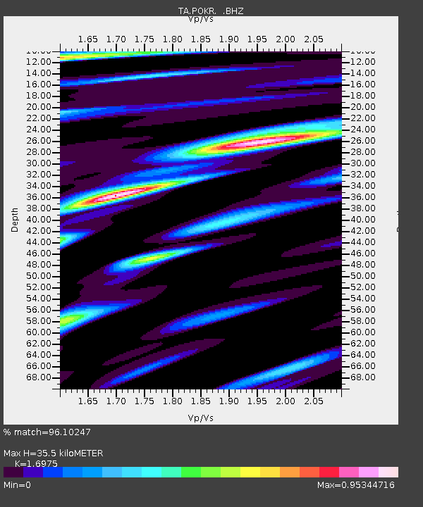
| Estimated Moho Depth: |
35.5 km |
| Estimated Crust Vp/Vs: |
1.70 |
| Assumed Crust Vp: |
6.566 km/s |
| Estimated Crust Vs: |
3.868 km/s |
| Estimated Crust Poisson's Ratio: |
0.23 |
|
| Radial Match: |
96.10247 % |
| Radial Bump: |
368 |
| Transverse Match: |
84.44625 % |
| Transverse Bump: |
400 |
| SOD ConfigId: |
976571 |
| Insert Time: |
2015-06-22 06:29:14.191 +0000 |
| GWidth: |
2.5 |
| Max Bumps: |
400 |
| Tol: |
0.001 |
|

Signal To Noise
| Channel | StoN | STA | LTA |
| TA:POKR: :BHZ:20150608T06:08:51.575012Z | 15.035136 | 5.461284E-7 | 3.6323478E-8 |
| TA:POKR: :BHN:20150608T06:08:51.575012Z | 2.9994626 | 1.1958242E-7 | 3.986795E-8 |
| TA:POKR: :BHE:20150608T06:08:51.575012Z | 7.710386 | 2.8955427E-7 | 3.75538E-8 |
| Arrivals |
| Ps | 4.0 SECOND |
| PpPs | 14 SECOND |
| PsPs/PpSs | 18 SECOND |


