You are here: Home > Network List > IC - New China Digital Seismograph Network Stations List
> Station ENH Enshi, Hubei Province, China > Earthquake Result Viewer
ENH Enshi, Hubei Province, China - Earthquake Result Viewer

| Earthquake location: |
Irian Jaya, Indonesia |
| Earthquake latitude/longitude: |
-3.6/140.2 |
| Earthquake time(UTC): |
2002/10/17 (290) 17:52:44 GMT |
| Earthquake Depth: |
33 km |
| Earthquake Magnitude: |
5.6 MB, 6.2 MS, 6.3 MW, 6.3 MW |
| Earthquake Catalog/Contributor: |
WHDF/NEIC |
|
| Network: |
IC New China Digital Seismograph Network |
| Station: |
ENH Enshi, Hubei Province, China |
| Lat/Lon: |
30.27 N/109.49 E |
| Elevation: |
487 m |
|
| Distance: |
44.7 deg |
| Az: |
321.046 deg |
| Baz: |
133.505 deg |
| Ray Param: |
0.07169473 |
| Estimated Moho Depth: |
47.0 km |
| Estimated Crust Vp/Vs: |
1.60 |
| Assumed Crust Vp: |
6.083 km/s |
| Estimated Crust Vs: |
3.802 km/s |
| Estimated Crust Poisson's Ratio: |
0.18 |
|
| Radial Match: |
91.83627 % |
| Radial Bump: |
400 |
| Transverse Match: |
78.29753 % |
| Transverse Bump: |
400 |
| SOD ConfigId: |
4714 |
| Insert Time: |
2010-03-04 21:47:27.146 +0000 |
| GWidth: |
2.5 |
| Max Bumps: |
400 |
| Tol: |
0.001 |
|
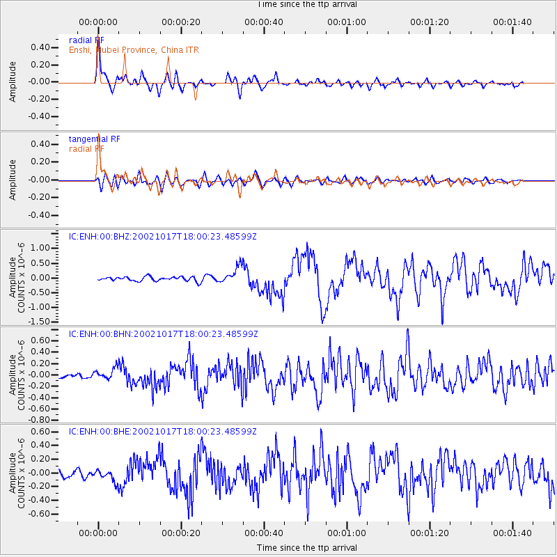
Signal To Noise
| Channel | StoN | STA | LTA |
| IC:ENH:00:BHN:20021017T18:00:23.48599Z | 3.0657654 | 1.02009366E-7 | 3.3273704E-8 |
| IC:ENH:00:BHE:20021017T18:00:23.48599Z | 1.9354322 | 9.14063E-8 | 4.722785E-8 |
| IC:ENH:00:BHZ:20021017T18:00:23.48599Z | 4.055368 | 2.9546055E-7 | 7.285665E-8 |
| Arrivals |
| Ps | 4.9 SECOND |
| PpPs | 19 SECOND |
| PsPs/PpSs | 24 SECOND |


