You are here: Home > Network List > 7A - Mid-Atlantic Geophysical Integrative Collaboration Stations List
> Station BARB Louisa, Virginia USA > Earthquake Result Viewer
BARB Louisa, Virginia USA - Earthquake Result Viewer
| Earthquake location: |
Off Coast Of Central Chile |
| Earthquake latitude/longitude: |
-29.4/-72.1 |
| Earthquake time(UTC): |
2015/11/11 (315) 01:54:37 GMT |
| Earthquake Depth: |
10 km |
| Earthquake Magnitude: |
6.9 MWW, 6.6 MI |
| Earthquake Catalog/Contributor: |
NEIC PDE/NEIC COMCAT |
|
| Network: |
7A Mid-Atlantic Geophysical Integrative Collaboration |
| Station: |
BARB Louisa, Virginia USA |
| Lat/Lon: |
37.99 N/78.09 W |
| Elevation: |
84 m |
|
| Distance: |
67.3 deg |
| Az: |
354.881 deg |
| Baz: |
174.347 deg |
| Ray Param: |
0.057038423 |
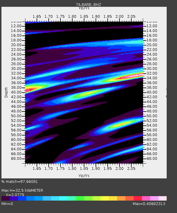
| Estimated Moho Depth: |
32.5 km |
| Estimated Crust Vp/Vs: |
2.08 |
| Assumed Crust Vp: |
6.419 km/s |
| Estimated Crust Vs: |
3.09 km/s |
| Estimated Crust Poisson's Ratio: |
0.35 |
|
| Radial Match: |
97.66081 % |
| Radial Bump: |
187 |
| Transverse Match: |
86.12916 % |
| Transverse Bump: |
400 |
| SOD ConfigId: |
7422571 |
| Insert Time: |
2019-04-21 08:04:35.255 +0000 |
| GWidth: |
2.5 |
| Max Bumps: |
400 |
| Tol: |
0.001 |
|

Signal To Noise
| Channel | StoN | STA | LTA |
| 7A:BARB: :BHZ:20151111T02:05:02.43998Z | 7.4560566 | 1.2383838E-6 | 1.66091E-7 |
| 7A:BARB: :BHN:20151111T02:05:02.43998Z | 3.6882713 | 5.1914674E-7 | 1.4075611E-7 |
| 7A:BARB: :BHE:20151111T02:05:02.43998Z | 1.2789427 | 1.8289276E-7 | 1.4300309E-7 |
| Arrivals |
| Ps | 5.6 SECOND |
| PpPs | 15 SECOND |
| PsPs/PpSs | 21 SECOND |


