ENH Enshi, Hubei Province, China - Earthquake Result Viewer
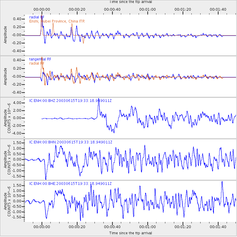
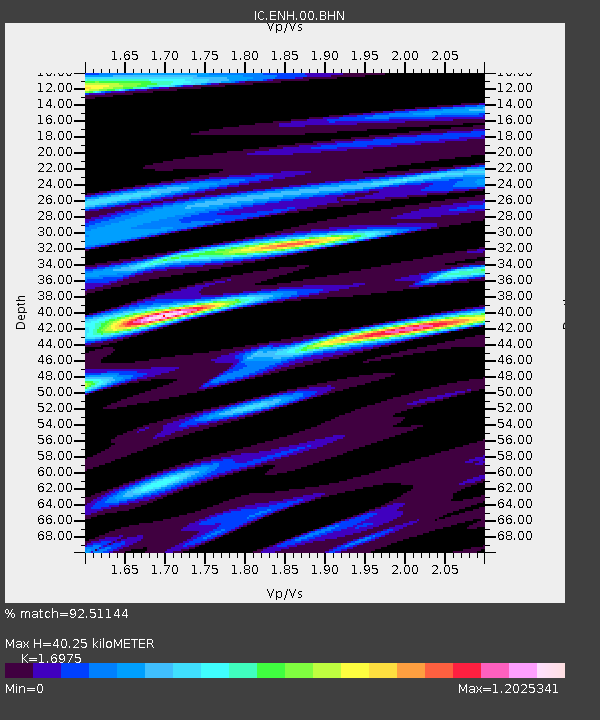
Earthquake location: Rat Islands, Aleutian Islands
Earthquake latitude/longitude: 51.6/176.9
Earthquake time(UTC): 2003/06/15 (166) 19:24:33 GMT
Earthquake Depth: 20 km
Earthquake Magnitude: 6.0 MB, 6.4 MS, 6.5 MW, 6.5 MW
Earthquake Catalog/Contributor: WHDF/NEIC
Network: IC New China Digital Seismograph Network
Station: ENH Enshi, Hubei Province, China
Lat/Lon: 30.27 N/109.49 E
Elevation: 487 m
Distance: 53.2 deg
Az: 273.858 deg
Baz: 46.061 deg
Ray Param: 0.06623613
Estimated Moho Depth: 40.25 km
Estimated Crust Vp/Vs: 1.70
Assumed Crust Vp: 6.083 km/s
Estimated Crust Vs: 3.583 km/s
Estimated Crust Poisson's Ratio: 0.23
Radial Match: 92.51144 %
Radial Bump: 400
Transverse Match: 82.19625 %
Transverse Bump: 400
SOD ConfigId: 4714
Insert Time: 2010-03-04 21:47:38.996 +0000
GWidth: 2.5
Max Bumps: 400
Tol: 0.001

Signal To Noise

ChannelStoNSTALTA
IC:ENH:00:BHN:20030615T19:33:18.949011Z11.7572826.8808424E-75.852409E-8
IC:ENH:00:BHE:20030615T19:33:18.949011Z8.9977236.9066766E-77.676027E-8
IC:ENH:00:BHZ:20030615T19:33:18.949011Z28.20371.8958513E-66.721995E-8
Arrivals
Ps4.9 SECOND
PpPs17 SECOND
PsPs/PpSs22 SECOND