You are here: Home > Network List > IW - Intermountain West Stations List
> Station MOOW Moose Ponds, Wyoming, USA > Earthquake Result Viewer
MOOW Moose Ponds, Wyoming, USA - Earthquake Result Viewer
| Earthquake location: |
Off Coast Of Central Chile |
| Earthquake latitude/longitude: |
-29.4/-72.1 |
| Earthquake time(UTC): |
2015/11/11 (315) 01:54:37 GMT |
| Earthquake Depth: |
10 km |
| Earthquake Magnitude: |
6.9 MWW, 6.6 MI |
| Earthquake Catalog/Contributor: |
NEIC PDE/NEIC COMCAT |
|
| Network: |
IW Intermountain West |
| Station: |
MOOW Moose Ponds, Wyoming, USA |
| Lat/Lon: |
43.75 N/110.74 W |
| Elevation: |
2128 m |
|
| Distance: |
81.0 deg |
| Az: |
332.73 deg |
| Baz: |
146.531 deg |
| Ray Param: |
0.047909573 |
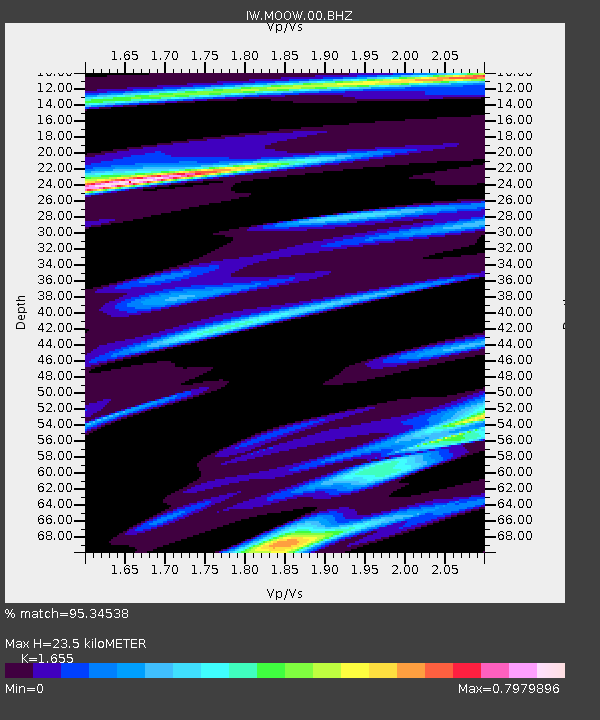
| Estimated Moho Depth: |
23.5 km |
| Estimated Crust Vp/Vs: |
1.65 |
| Assumed Crust Vp: |
6.207 km/s |
| Estimated Crust Vs: |
3.75 km/s |
| Estimated Crust Poisson's Ratio: |
0.21 |
|
| Radial Match: |
95.34538 % |
| Radial Bump: |
370 |
| Transverse Match: |
79.20514 % |
| Transverse Bump: |
400 |
| SOD ConfigId: |
7422571 |
| Insert Time: |
2019-04-21 08:07:41.909 +0000 |
| GWidth: |
2.5 |
| Max Bumps: |
400 |
| Tol: |
0.001 |
|

Signal To Noise
| Channel | StoN | STA | LTA |
| IW:MOOW:00:BHZ:20151111T02:06:22.019021Z | 1.8566177 | 2.3548854E-7 | 1.2683739E-7 |
| IW:MOOW:00:BH1:20151111T02:06:22.019021Z | 0.61726534 | 7.896796E-8 | 1.2793194E-7 |
| IW:MOOW:00:BH2:20151111T02:06:22.019021Z | 1.0491594 | 9.784123E-8 | 9.325678E-8 |
| Arrivals |
| Ps | 2.5 SECOND |
| PpPs | 9.8 SECOND |
| PsPs/PpSs | 12 SECOND |


