You are here: Home > Network List > IC - New China Digital Seismograph Network Stations List
> Station ENH Enshi, Hubei Province, China > Earthquake Result Viewer
ENH Enshi, Hubei Province, China - Earthquake Result Viewer
| Earthquake location: |
Solomon Islands |
| Earthquake latitude/longitude: |
-11.1/162.2 |
| Earthquake time(UTC): |
2004/11/11 (316) 17:34:52 GMT |
| Earthquake Depth: |
10 km |
| Earthquake Magnitude: |
5.8 MB, 6.6 MS, 6.7 MW, 6.6 MW |
| Earthquake Catalog/Contributor: |
WHDF/NEIC |
|
| Network: |
IC New China Digital Seismograph Network |
| Station: |
ENH Enshi, Hubei Province, China |
| Lat/Lon: |
30.27 N/109.49 E |
| Elevation: |
487 m |
|
| Distance: |
65.3 deg |
| Az: |
310.732 deg |
| Baz: |
120.72 deg |
| Ray Param: |
0.05837165 |
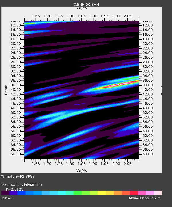
| Estimated Moho Depth: |
37.5 km |
| Estimated Crust Vp/Vs: |
2.01 |
| Assumed Crust Vp: |
6.083 km/s |
| Estimated Crust Vs: |
3.023 km/s |
| Estimated Crust Poisson's Ratio: |
0.34 |
|
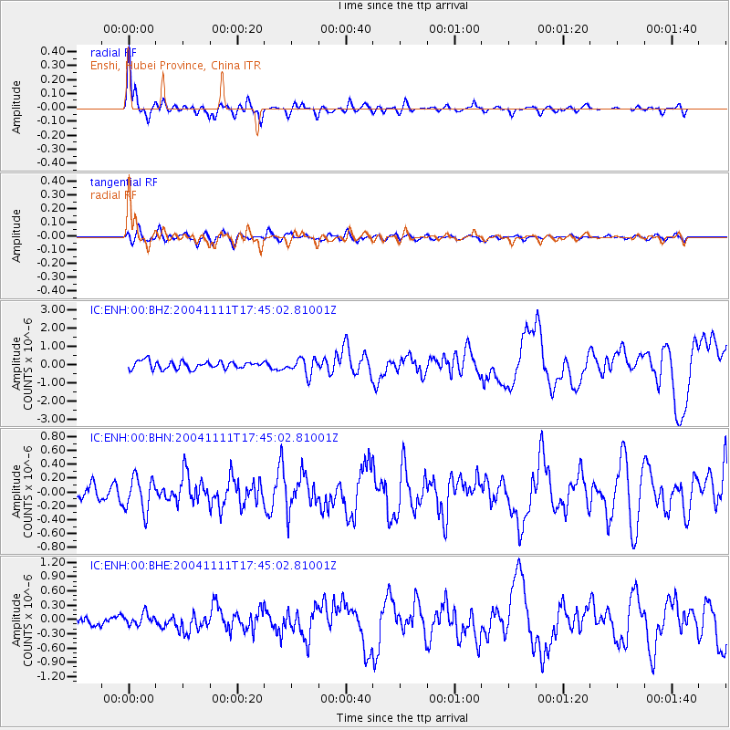
| Radial Match: |
92.3988 % |
| Radial Bump: |
400 |
| Transverse Match: |
75.88349 % |
| Transverse Bump: |
400 |
| SOD ConfigId: |
2459 |
| Insert Time: |
2010-03-04 21:48:22.114 +0000 |
| GWidth: |
2.5 |
| Max Bumps: |
400 |
| Tol: |
0.001 |
|
Signal To Noise
| Channel | StoN | STA | LTA |
| IC:ENH:00:BHN:20041111T17:45:02.81001Z | 2.8427258 | 2.46073E-7 | 8.6562345E-8 |
| IC:ENH:00:BHE:20041111T17:45:02.81001Z | 1.2037988 | 1.2539167E-7 | 1.04163306E-7 |
| IC:ENH:00:BHZ:20041111T17:45:02.81001Z | 2.1032152 | 4.4440023E-7 | 2.1129564E-7 |
| Arrivals |
| Ps | 6.4 SECOND |
| PpPs | 18 SECOND |
| PsPs/PpSs | 24 SECOND |


