You are here: Home > Network List > N4 - Central and EAstern US Network Stations List
> Station E63A Oxbow, ME, USA > Earthquake Result Viewer
E63A Oxbow, ME, USA - Earthquake Result Viewer
| Earthquake location: |
Off Coast Of Central Chile |
| Earthquake latitude/longitude: |
-29.4/-72.1 |
| Earthquake time(UTC): |
2015/11/11 (315) 01:54:37 GMT |
| Earthquake Depth: |
10 km |
| Earthquake Magnitude: |
6.9 MWW, 6.6 MI |
| Earthquake Catalog/Contributor: |
NEIC PDE/NEIC COMCAT |
|
| Network: |
N4 Central and EAstern US Network |
| Station: |
E63A Oxbow, ME, USA |
| Lat/Lon: |
46.42 N/68.46 W |
| Elevation: |
238 m |
|
| Distance: |
75.6 deg |
| Az: |
2.601 deg |
| Baz: |
183.281 deg |
| Ray Param: |
0.051575348 |
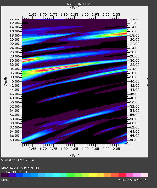
| Estimated Moho Depth: |
29.75 km |
| Estimated Crust Vp/Vs: |
1.60 |
| Assumed Crust Vp: |
6.419 km/s |
| Estimated Crust Vs: |
4.006 km/s |
| Estimated Crust Poisson's Ratio: |
0.18 |
|
| Radial Match: |
89.52359 % |
| Radial Bump: |
318 |
| Transverse Match: |
64.38685 % |
| Transverse Bump: |
400 |
| SOD ConfigId: |
7422571 |
| Insert Time: |
2019-04-21 08:08:48.382 +0000 |
| GWidth: |
2.5 |
| Max Bumps: |
400 |
| Tol: |
0.001 |
|

Signal To Noise
| Channel | StoN | STA | LTA |
| N4:E63A: :HHZ:20151111T02:05:52.059976Z | 2.1125484 | 1.0491301E-6 | 4.9661827E-7 |
| N4:E63A: :HHN:20151111T02:05:52.059976Z | 1.8734509 | 5.4745993E-7 | 2.9222005E-7 |
| N4:E63A: :HHE:20151111T02:05:52.059976Z | 0.33913878 | 1.1965513E-7 | 3.5282056E-7 |
| Arrivals |
| Ps | 2.9 SECOND |
| PpPs | 12 SECOND |
| PsPs/PpSs | 15 SECOND |


