You are here: Home > Network List > IC - New China Digital Seismograph Network Stations List
> Station ENH Enshi, Hubei Province, China > Earthquake Result Viewer
ENH Enshi, Hubei Province, China - Earthquake Result Viewer
| Earthquake location: |
Southeast Of Loyalty Islands |
| Earthquake latitude/longitude: |
-22.0/170.3 |
| Earthquake time(UTC): |
2004/05/07 (128) 01:26:42 GMT |
| Earthquake Depth: |
14 km |
| Earthquake Magnitude: |
5.7 MB, 6.2 MS, 6.3 MW, 6.2 MW |
| Earthquake Catalog/Contributor: |
WHDF/NEIC |
|
| Network: |
IC New China Digital Seismograph Network |
| Station: |
ENH Enshi, Hubei Province, China |
| Lat/Lon: |
30.27 N/109.49 E |
| Elevation: |
487 m |
|
| Distance: |
78.2 deg |
| Az: |
309.511 deg |
| Baz: |
124.136 deg |
| Ray Param: |
0.049821787 |
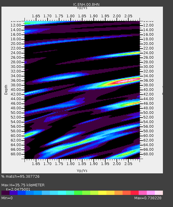
| Estimated Moho Depth: |
35.75 km |
| Estimated Crust Vp/Vs: |
2.05 |
| Assumed Crust Vp: |
6.083 km/s |
| Estimated Crust Vs: |
2.971 km/s |
| Estimated Crust Poisson's Ratio: |
0.34 |
|
| Radial Match: |
95.387726 % |
| Radial Bump: |
400 |
| Transverse Match: |
87.7248 % |
| Transverse Bump: |
400 |
| SOD ConfigId: |
2459 |
| Insert Time: |
2010-03-04 21:48:41.275 +0000 |
| GWidth: |
2.5 |
| Max Bumps: |
400 |
| Tol: |
0.001 |
|

Signal To Noise
| Channel | StoN | STA | LTA |
| IC:ENH:00:BHN:20040507T01:38:09.535022Z | 6.4096518 | 2.5942666E-7 | 4.047438E-8 |
| IC:ENH:00:BHE:20040507T01:38:09.535022Z | 6.7457194 | 3.323452E-7 | 4.926757E-8 |
| IC:ENH:00:BHZ:20040507T01:38:09.535022Z | 33.63019 | 1.6248499E-6 | 4.831522E-8 |
| Arrivals |
| Ps | 6.3 SECOND |
| PpPs | 18 SECOND |
| PsPs/PpSs | 24 SECOND |


