You are here: Home > Network List > N4 - Central and EAstern US Network Stations List
> Station L59A Walton, NY, USA > Earthquake Result Viewer
L59A Walton, NY, USA - Earthquake Result Viewer
| Earthquake location: |
Off Coast Of Central Chile |
| Earthquake latitude/longitude: |
-29.4/-72.1 |
| Earthquake time(UTC): |
2015/11/11 (315) 01:54:37 GMT |
| Earthquake Depth: |
10 km |
| Earthquake Magnitude: |
6.9 MWW, 6.6 MI |
| Earthquake Catalog/Contributor: |
NEIC PDE/NEIC COMCAT |
|
| Network: |
N4 Central and EAstern US Network |
| Station: |
L59A Walton, NY, USA |
| Lat/Lon: |
42.19 N/75.04 W |
| Elevation: |
677 m |
|
| Distance: |
71.3 deg |
| Az: |
357.696 deg |
| Baz: |
177.296 deg |
| Ray Param: |
0.05440375 |
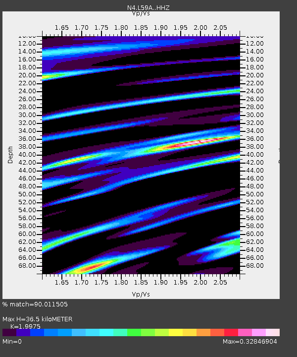
| Estimated Moho Depth: |
36.5 km |
| Estimated Crust Vp/Vs: |
2.00 |
| Assumed Crust Vp: |
6.419 km/s |
| Estimated Crust Vs: |
3.214 km/s |
| Estimated Crust Poisson's Ratio: |
0.33 |
|
| Radial Match: |
90.011505 % |
| Radial Bump: |
272 |
| Transverse Match: |
85.61241 % |
| Transverse Bump: |
362 |
| SOD ConfigId: |
7422571 |
| Insert Time: |
2019-04-21 08:09:20.849 +0000 |
| GWidth: |
2.5 |
| Max Bumps: |
400 |
| Tol: |
0.001 |
|

Signal To Noise
| Channel | StoN | STA | LTA |
| N4:L59A: :HHZ:20151111T02:05:27.160012Z | 3.692255 | 9.93932E-7 | 2.6919375E-7 |
| N4:L59A: :HHN:20151111T02:05:27.160012Z | 1.4444454 | 4.2362635E-7 | 2.932796E-7 |
| N4:L59A: :HHE:20151111T02:05:27.160012Z | 1.0303615 | 2.9836724E-7 | 2.8957527E-7 |
| Arrivals |
| Ps | 5.9 SECOND |
| PpPs | 17 SECOND |
| PsPs/PpSs | 22 SECOND |


