You are here: Home > Network List > IC - New China Digital Seismograph Network Stations List
> Station ENH Enshi, Hubei Province, China > Earthquake Result Viewer
ENH Enshi, Hubei Province, China - Earthquake Result Viewer
| Earthquake location: |
Hokkaido, Japan Region |
| Earthquake latitude/longitude: |
42.9/144.8 |
| Earthquake time(UTC): |
2004/04/11 (102) 18:06:12 GMT |
| Earthquake Depth: |
42 km |
| Earthquake Magnitude: |
5.7 MB, 5.7 MS, 6.1 MW, 6.1 MW |
| Earthquake Catalog/Contributor: |
WHDF/NEIC |
|
| Network: |
IC New China Digital Seismograph Network |
| Station: |
ENH Enshi, Hubei Province, China |
| Lat/Lon: |
30.27 N/109.49 E |
| Elevation: |
487 m |
|
| Distance: |
30.8 deg |
| Az: |
257.573 deg |
| Baz: |
56.022 deg |
| Ray Param: |
0.07918124 |
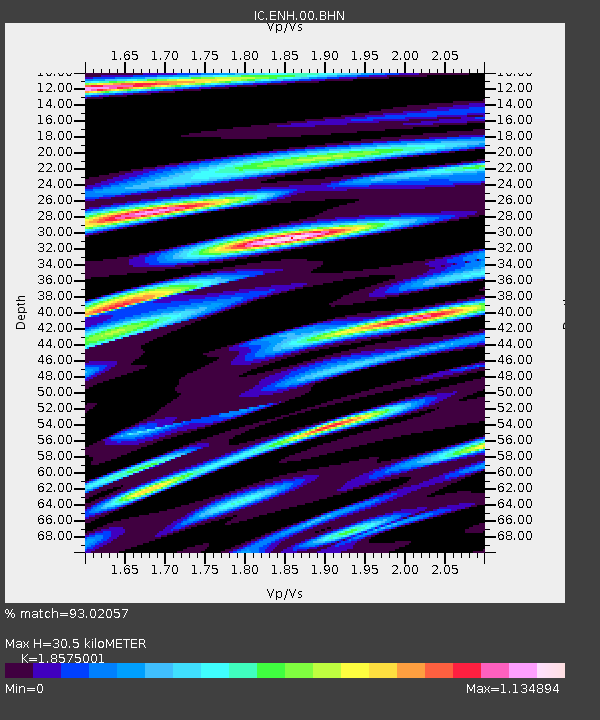
| Estimated Moho Depth: |
30.5 km |
| Estimated Crust Vp/Vs: |
1.86 |
| Assumed Crust Vp: |
6.083 km/s |
| Estimated Crust Vs: |
3.275 km/s |
| Estimated Crust Poisson's Ratio: |
0.30 |
|
| Radial Match: |
93.02057 % |
| Radial Bump: |
400 |
| Transverse Match: |
88.02811 % |
| Transverse Bump: |
400 |
| SOD ConfigId: |
2459 |
| Insert Time: |
2010-03-04 21:48:49.047 +0000 |
| GWidth: |
2.5 |
| Max Bumps: |
400 |
| Tol: |
0.001 |
|
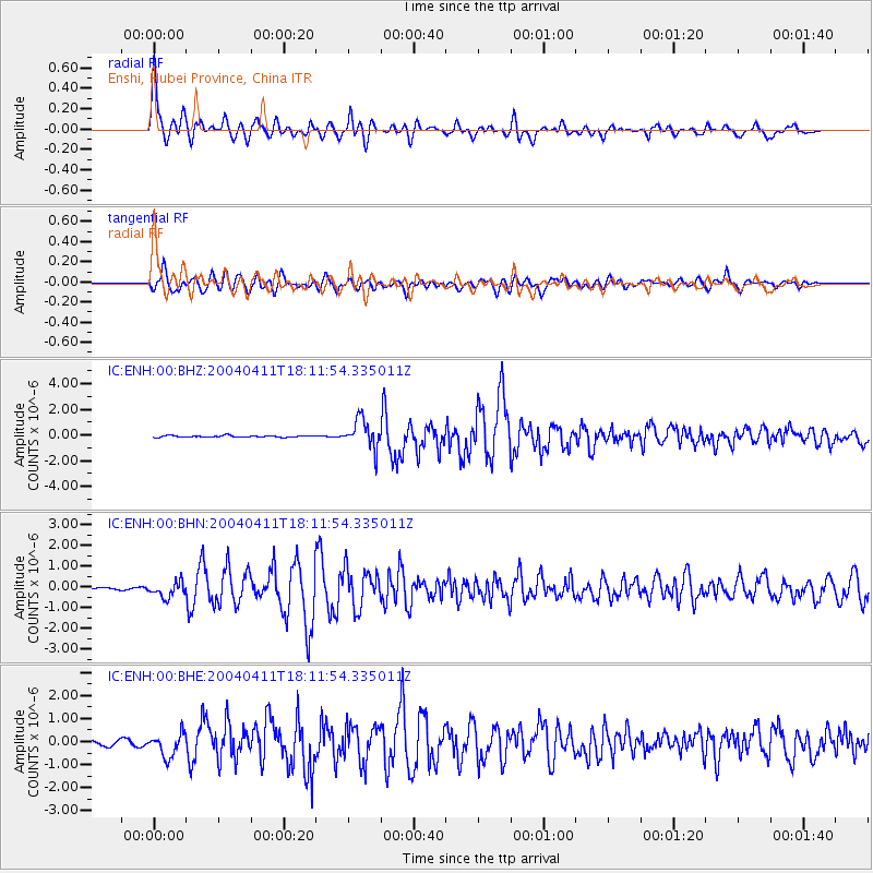
Signal To Noise
| Channel | StoN | STA | LTA |
| IC:ENH:00:BHN:20040411T18:11:54.335011Z | 6.1403146 | 3.6147938E-7 | 5.8869848E-8 |
| IC:ENH:00:BHE:20040411T18:11:54.335011Z | 6.532762 | 5.015954E-7 | 7.678152E-8 |
| IC:ENH:00:BHZ:20040411T18:11:54.335011Z | 18.436739 | 1.1192184E-6 | 6.070587E-8 |
| Arrivals |
| Ps | 4.6 SECOND |
| PpPs | 13 SECOND |
| PsPs/PpSs | 18 SECOND |


