You are here: Home > Network List > IC - New China Digital Seismograph Network Stations List
> Station ENH Enshi, Hubei Province, China > Earthquake Result Viewer
ENH Enshi, Hubei Province, China - Earthquake Result Viewer

| Earthquake location: |
Tonga Islands |
| Earthquake latitude/longitude: |
-16.8/-174.2 |
| Earthquake time(UTC): |
2004/01/25 (025) 11:43:11 GMT |
| Earthquake Depth: |
130 km |
| Earthquake Magnitude: |
6.4 MB, 6.7 MW, 6.7 MW |
| Earthquake Catalog/Contributor: |
WHDF/NEIC |
|
| Network: |
IC New China Digital Seismograph Network |
| Station: |
ENH Enshi, Hubei Province, China |
| Lat/Lon: |
30.27 N/109.49 E |
| Elevation: |
487 m |
|
| Distance: |
87.0 deg |
| Az: |
302.682 deg |
| Baz: |
111.288 deg |
| Ray Param: |
0.04333187 |
| Estimated Moho Depth: |
37.25 km |
| Estimated Crust Vp/Vs: |
1.96 |
| Assumed Crust Vp: |
6.083 km/s |
| Estimated Crust Vs: |
3.107 km/s |
| Estimated Crust Poisson's Ratio: |
0.32 |
|
| Radial Match: |
93.8974 % |
| Radial Bump: |
352 |
| Transverse Match: |
92.15707 % |
| Transverse Bump: |
356 |
| SOD ConfigId: |
2459 |
| Insert Time: |
2010-03-04 21:48:58.328 +0000 |
| GWidth: |
2.5 |
| Max Bumps: |
400 |
| Tol: |
0.001 |
|
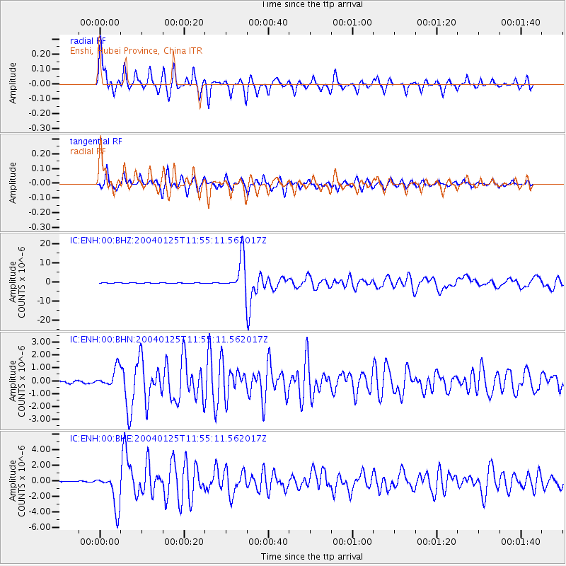
Signal To Noise
| Channel | StoN | STA | LTA |
| IC:ENH:00:BHN:20040125T11:55:11.562017Z | 7.9167795 | 7.768745E-7 | 9.8130116E-8 |
| IC:ENH:00:BHE:20040125T11:55:11.562017Z | 50.49893 | 2.332115E-6 | 4.6181473E-8 |
| IC:ENH:00:BHZ:20040125T11:55:11.562017Z | 87.18428 | 9.288156E-6 | 1.0653476E-7 |
| Arrivals |
| Ps | 6.0 SECOND |
| PpPs | 18 SECOND |
| PsPs/PpSs | 24 SECOND |


