You are here: Home > Network List > NE - New England Seismic Network Stations List
> Station BCX Chestnut Hill, MA, USA > Earthquake Result Viewer
BCX Chestnut Hill, MA, USA - Earthquake Result Viewer
| Earthquake location: |
Off Coast Of Central Chile |
| Earthquake latitude/longitude: |
-29.4/-72.1 |
| Earthquake time(UTC): |
2015/11/11 (315) 01:54:37 GMT |
| Earthquake Depth: |
10 km |
| Earthquake Magnitude: |
6.9 MWW, 6.6 MI |
| Earthquake Catalog/Contributor: |
NEIC PDE/NEIC COMCAT |
|
| Network: |
NE New England Seismic Network |
| Station: |
BCX Chestnut Hill, MA, USA |
| Lat/Lon: |
42.33 N/71.17 W |
| Elevation: |
60 m |
|
| Distance: |
71.4 deg |
| Az: |
0.731 deg |
| Baz: |
180.86 deg |
| Ray Param: |
0.05433798 |
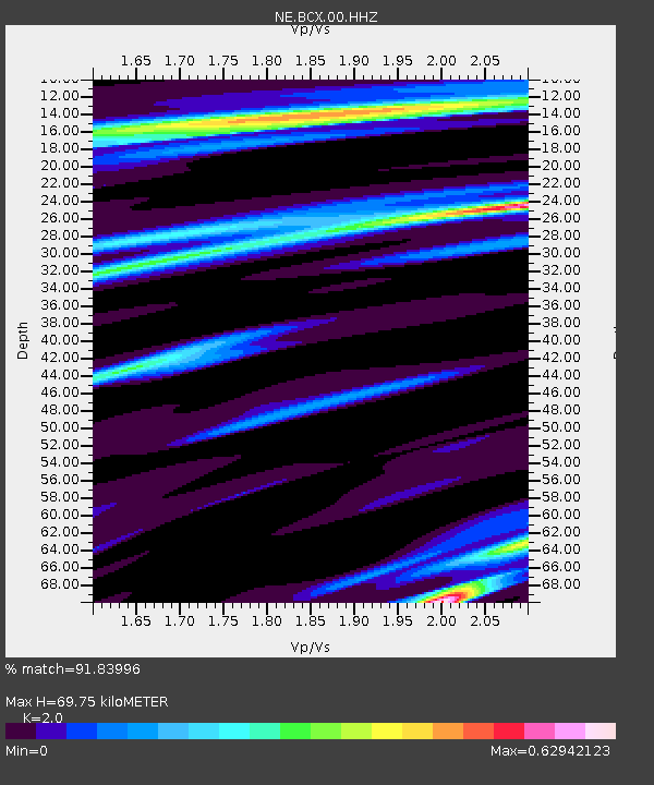
| Estimated Moho Depth: |
69.75 km |
| Estimated Crust Vp/Vs: |
2.00 |
| Assumed Crust Vp: |
6.419 km/s |
| Estimated Crust Vs: |
3.21 km/s |
| Estimated Crust Poisson's Ratio: |
0.33 |
|
| Radial Match: |
91.83996 % |
| Radial Bump: |
319 |
| Transverse Match: |
69.82277 % |
| Transverse Bump: |
400 |
| SOD ConfigId: |
7422571 |
| Insert Time: |
2019-04-21 08:10:30.466 +0000 |
| GWidth: |
2.5 |
| Max Bumps: |
400 |
| Tol: |
0.001 |
|

Signal To Noise
| Channel | StoN | STA | LTA |
| NE:BCX:00:HHZ:20151111T02:05:27.723977Z | 2.4625788 | 8.5947306E-7 | 3.4901342E-7 |
| NE:BCX:00:HH1:20151111T02:05:27.723977Z | 1.2117542 | 4.2320679E-7 | 3.4925134E-7 |
| NE:BCX:00:HH2:20151111T02:05:27.723977Z | 1.1141405 | 2.3000926E-7 | 2.0644546E-7 |
| Arrivals |
| Ps | 11 SECOND |
| PpPs | 32 SECOND |
| PsPs/PpSs | 43 SECOND |


