You are here: Home > Network List > IC - New China Digital Seismograph Network Stations List
> Station ENH Enshi, Hubei Province, China > Earthquake Result Viewer
ENH Enshi, Hubei Province, China - Earthquake Result Viewer
| Earthquake location: |
Southern Sumatra, Indonesia |
| Earthquake latitude/longitude: |
-2.4/104.0 |
| Earthquake time(UTC): |
2004/07/25 (207) 14:35:19 GMT |
| Earthquake Depth: |
582 km |
| Earthquake Magnitude: |
6.8 MB, 7.3 MW, 7.3 MW |
| Earthquake Catalog/Contributor: |
WHDF/NEIC |
|
| Network: |
IC New China Digital Seismograph Network |
| Station: |
ENH Enshi, Hubei Province, China |
| Lat/Lon: |
30.27 N/109.49 E |
| Elevation: |
487 m |
|
| Distance: |
32.9 deg |
| Az: |
8.781 deg |
| Baz: |
190.155 deg |
| Ray Param: |
0.07562103 |
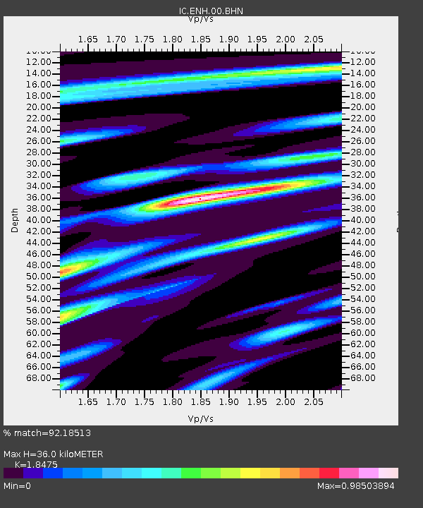
| Estimated Moho Depth: |
36.0 km |
| Estimated Crust Vp/Vs: |
1.85 |
| Assumed Crust Vp: |
6.083 km/s |
| Estimated Crust Vs: |
3.292 km/s |
| Estimated Crust Poisson's Ratio: |
0.29 |
|
| Radial Match: |
92.18513 % |
| Radial Bump: |
344 |
| Transverse Match: |
64.18064 % |
| Transverse Bump: |
400 |
| SOD ConfigId: |
2459 |
| Insert Time: |
2010-03-04 21:49:41.476 +0000 |
| GWidth: |
2.5 |
| Max Bumps: |
400 |
| Tol: |
0.001 |
|
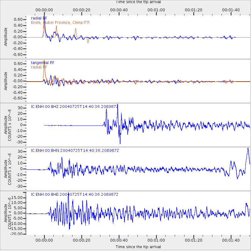
Signal To Noise
| Channel | StoN | STA | LTA |
| IC:ENH:00:BHN:20040725T14:40:36.208987Z | 43.734264 | 3.7434065E-6 | 8.5594365E-8 |
| IC:ENH:00:BHE:20040725T14:40:36.208987Z | 40.65351 | 2.0155983E-6 | 4.9579928E-8 |
| IC:ENH:00:BHZ:20040725T14:40:36.208987Z | 87.343475 | 9.281626E-6 | 1.0626582E-7 |
| Arrivals |
| Ps | 5.3 SECOND |
| PpPs | 16 SECOND |
| PsPs/PpSs | 21 SECOND |


